Map of France

Region Guyane

French version French Version : Guyane

Find a town, a zip code,
a department, a region... in France
I like Map-France.com !


Region of Guyane


Region Guyane

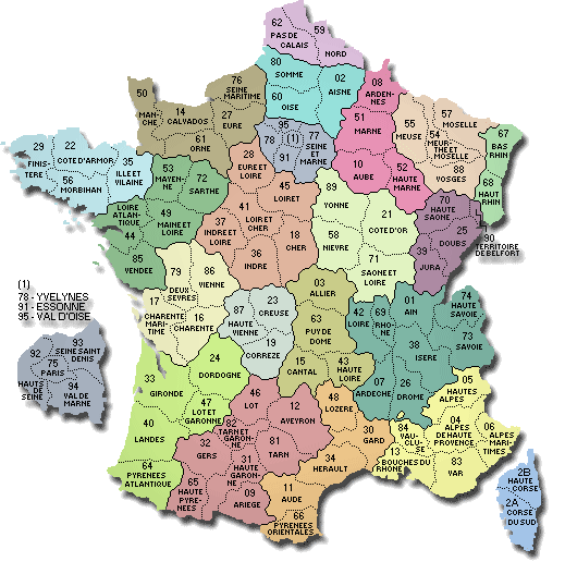
The region is the first level of administrative divisions on the France map. The region of Guyane is an overseas region of France, composed of a single department of the same name. The region of Guyane is both a region and a department.  The region of Guyane has the number 3 and is divided into 1 departments, 2 districts, 19 townships and 22 municipalities. Below you will find the localization of Guyane on the map of France, and the satellite map of Guyane.


Population of Guyane

Inhabitants of Guyane were 157 213 in the 1999 census and 205 954 in the 2006 census. Area of region of Guyane is 83 533,90 km ². Population density of Guyane is 2,47 inhabitants per km².

Biggest cities of region of Guyane, in number of inhabitants, are (2007 census): Cayenne (973), Saint-Laurent-du-Maroni (973), Kourou (973), Matoury (973), Remire-Montjoly (973), Mana (973), Macouria (973), Apatou (973), Maripasoula (973), Saint-Georges (973), Grand-Santi (973), Sinnamary (973), Roura (973), Papaichton (973), Iracoubo (973), Montsinéry-Tonnegrande (973), Camopi (973), Awala-Yalimapo (973), Régina (973), Saint-Élie (973), Saül (973), Ouanary (973).

You will find the towns list of Guyane in the bottom on this page. You can consult the map of France, pictures, hotels, and all data of every town and village in the region of Guyane clicking on these towns links.


I like the region of
Guyane !
   
Biggest cities of Guyane
Name of biggest cities
of Guyane


Census
(2007)


Area
(km ²)


Density
(inh/km²)


Altitude
(m)


Cayenne (973)58 00823.602 457.9753 m
Saint-Laurent-du-Maroni (973)34 1494 830.007.079 m
Kourou (973)25 6882 160.0011.8971 m
Matoury (973)24 893137.20181.44117 m
Remire-Montjoly (973)18 51146.11401.4552 m
Mana (973)8 2566 332.601.30318 m
Macouria (973)8 191378.0021.6752 m
Apatou (973)6 3572 020.003.15258 m
Maripasoula (973)5 54518 360.000.30462 m
Saint-Georges (973)3 6052 320.001.55191 m
Grand-Santi (973)3 4272 123.001.61383 m
Sinnamary (973)3 1101 340.002.32140 m
Roura (973)2 8233 685.000.77231 m
Papaichton (973)2 2962 628.000.87386 m
Iracoubo (973)1 9752 762.000.72203 m
Montsinéry-Tonnegrande (973)1 958737.202.6656 m
Camopi (973)1 46910 049.600.15445 m
Awala-Yalimapo (973)1 251187.406.685 m
Régina (973)82612 130.000.07356 m
Saint-Élie (973)4505 680.000.08335 m
Saül (973)1584 475.000.04350 m
Ouanary (973)851 080.000.08171 m
Statistics of region of Guyane
Population 1999 157 213 inhabitants  
Population 2006 205 954 inhabitants  
Area 83 533.90 km ²  
Population density 2.47 inhabs/km² Map France population density
Variation of density +3.93 % Map France population variation density
     
Administration of region of Guyane
Number 3  
Prefecture Cayenne  
Subprefectures Cayenne Map of France cities
Departments Guyane (973) Map of France departments
     
Subdivisions of the region of Guyane
Departments 1  
Districts 2  
Townships 19  
Municipalities 22  


Hotel Guyane

Search hotels of Guyane : Book your hotel now !

Where ? 

Check-in date 
calendar
Check-out date 
calendar


Map of Guyane

MAP OF THE REGION GUYANE
map region Guyane

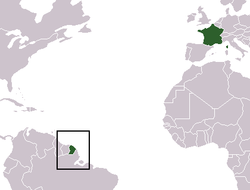
Where is located the Guyane region ?
French Guiana (Guyane française) is an overseas region of France, consisting of a single overseas department located on the northern Atlantic coast of South America. It has borders with two nations, Brazil to the east and south, and Suriname to the west. Its 83,534 km² have a very low population density of less than three inhabitants per km², with almost half of its 229,000 people in 2009 living in the urban area of Cayenne, its capital. French Guiana's currency is the euro. You can find French Guiana on the world map bellow.


What are the statistics and key data of Guyane ?
The region of Guyane has the number 3. It is composed of 1 departments, 2 districts ("arrondissements"), 19 townships ("cantons") and 22 towns ("communes").
The 1 departments of the region of Guyane are: Guyane (973)

Inhabitants of Guyane were 157 213 in 1999 and 205 954 in 2006. The area of the region Guyane is 83 533,90 km ². The population density of the region Guyane is 2,47 inhabitants per km².


What are the largest cities of the region of Guyane ?
The largest cities of the region of Guyane (compared to the number of inhabitants in 2007) are : Cayenne (973), Saint-Laurent-du-Maroni (973), Kourou (973), Matoury (973), Remire-Montjoly (973), Mana (973), Macouria (973), Apatou (973), Maripasoula (973), Saint-Georges (973), Grand-Santi (973), Sinnamary (973), Roura (973), Papaichton (973), Iracoubo (973), Montsinéry-Tonnegrande (973), Camopi (973), Awala-Yalimapo (973), Régina (973), Saint-Élie (973), Saül (973), Ouanary (973).


Interactive map of the Guyane region
You can zoom the satellite map of Guyane to see a village or a city, for example Cayenne.

Search a town of region Guyane


Records of the Guyane region: Did you know ?


The town with the longest name of the region of Guyane is: Saint-Laurent-du-Maroni
The town with the shortest name of the region of Guyane is: Mana
The municipality with the highest altitude of the department region of Guyane is: Maripasoula with 462 m
The municipality with the lowest altitude of the region of Guyane is: Awala-Yalimapo with 5 m
The municipality with the largest area of the region of Guyane is: Maripasoula with 18360.00 km ²
The municipality with the smallest area of the region of Guyane is: Cayenne with 23.60 km ²


Towns list of the Guyane region

Follow the links of towns and cities of the Guyane region and see photos, maps, and informations for these towns.


Towns of region Guyane in A
ApatouAwala-Yalimapo


Towns of region Guyane in C
CamopiCayenne


Towns of region Guyane in G
Grand-Santi


Towns of region Guyane in I
Iracoubo


Towns of region Guyane in K
Kourou


Towns of region Guyane in M
MacouriaManaMaripasoulaMatoury
Montsinéry-Tonnegrande


Towns of region Guyane in O
Ouanary


Towns of region Guyane in P
Papaichton


Towns of region Guyane in R
RéginaRemire-MontjolyRoura


Towns of region Guyane in S
Saint-ÉlieSaint-GeorgesSaint-Laurent-du-MaroniSaül
Sinnamary


List of french departments


Ain
Aisne
Allier
Alpes de Haute-Provence
Hautes-Alpes
Alpes Maritimes
Ardèche
Ardennes
Ariège
Aube
Aude
Aveyron
Bouches-du-Rhône
Calvados
Cantal
Charente
Charente-Maritime
Cher
Corrèze
Corse-du-Sud
HauteCorse
Côte-d'Or
Côtes d'Armor
Creuse
Dordogne

Doubs
Drôme
Eure
Eure-et-Loir
Finistère
Gard
Haute Garonne
Gers
Gironde
Hérault
Ille-et-Vilaine
Indre
Indre-et-Loire
Isère
Jura
Landes
Loir-et-Cher
Loire
Haute Loire
Loire Atlantique
Loiret
Lot
Lot-et-Garonne
Lozère
Maine-et-Loire

Manche
Marne
HauteMarne
Mayenne
Meurthe-et-Moselle
Meuse
Morbihan
Moselle
Nièvre
Nord
Oise
Orne
Pas-de-Calais
Puy-de-Dôme
Pyrénées Atlantiques
Hautes Pyrénées
Pyrénées Orientales
Bas-Rhin
Haut-Rhin
Rhône
Haute Saône
Saône-et-Loire
Sarthe
Savoie
Haute Savoie

Paris
Seine Maritime
Seine-et-Marne
Yvelines
Deux-Sèvres
Somme
Tarn
Tarn-et-Garonne
Var
Vaucluse
Vendée
Vienne
Haute Vienne
Vosges
Yonne
Territoire de Belfort
Essonne
Hauts-de-Seine
Seine-St-Denis
Val-de-Marne
Val-D'Oise
Guadeloupe
Martinique
Guyane
La-Reunion
Mayotte


Other regions, departments, maps, hotels and towns in france


Find another town, zip code, department, region, ...


Back to the menus Map of France :


Make a link to this pageSinnamary with the following code :


Find a town in France by clicking on the following interactives maps :


MAP OF FRANCE REGION


Map of french regions


Map of french regions Alsace Lorraine Franche Comte Champagne Ardenne Nord pas de Calais Picardie Haute Normandie Basse Normandie Bretagne Pays de la Loire Poitou Charentes Limousin Centre Ile de France Bourgogne Rhone Alpes Auvergne Provence Midi Pyrenees Aquitaine Languedoc Rousillon Corse

MAP OF FRANCE DEPARTMENT


Map of french departments
Map of french departments Map France department Nord 59 [15] Map France department Pas de Calais 62 [15] Map France department Somme 80 [19] Map France department Aisne 02 [19] Map France department Oise 60 [19] Map France department Seine Maritime 76 [17] Map France department Eure 27 [17] Map France department Ardennes 08 [07] Map France department Marne 51 [07] Map France department Aube 10 [07] Map France department Haute Marne 52 [07] Map France department Meuse 55 [13] Map France department Meurthe et Moselle 54 [13] Map France department Moselle 57 [13] Map France department Vosges 88 [13] Map France department Bas Rhin 67 [01] Map France department Haut Rhin 68 [01] Map France department Territoire de Belfort 90 [09] Map France department Haute Saône 70 [09] Map France department Doubs 25 [09] Map France department Jura 39 [09] Map France department Haute Savoie 74 [22] Map France department Ain 01 [22] Map France department Rhône 69 [22] Map France department Loire 42 [22] Map France department Savoie 73 [22] Map France department Isère 38 [22] Map France department Drôme 26 [22] Map France department Ardèche 07 [22] Map France department Hautes Alpes 05 [21] Map France department Alpes de Haute Provence 04 [21] Map France department Alpes Maritimes 06 [21] Map France department Var 83 [21] Map France department Vaucluse 84 [21] Map France department Bouches du Rhône 13 [21] Map France department Haute Corse 2B [08] Map France department Corse du Sud 2A [08] Map France department Yonne 89 [04] Map France department Côte d'Or 21 [04] Map France department Saône et Loire 71 [04] Map France department Nièvre 58 [04] Map France department Calvados 14 [16] Map France department Manche 50 [16] Map France department Orne 61 [16] Map France department Eure et Loir [06] Map France department Loiret 45 [06] Map France department Loir et Cher 41 [06] Map France department Cher 18 [06] Map France department Indre et Loire 37 [06] Map France department Indre 36 [06] Map France department Allier 03 [03] Map France department Puy de Dôme 63 [03] Map France department Haute Loire 43 [03] Map France department Cantal 15 [03] Map France department Finistère 29 [05] Map France department Côtes d'Armor 22 [05] Map France department Ille et Vilaine 35 [05] Map France department Morbihan 56 [05] Map France department Mayenne 53 [18] Map France department Sarthe 72 [18] Map France department Maine et Loire 49 [18] Map France department Loire Atlantique 44 [18] Map France department Vendée 85 [18] Map France department Deux sèvres 79 [20] Map France department Vienne 86 [20] Map France department Charente Maritime 17 [20] Map France department Charente 16 [20] Map France department Creuse 23 [12] Map France department Haute Vienne 87 [12] Map France department Corrèze 19 [12] Map France department Dordogne 24 [02] Map France department Gironde 33 [02] Map France department Lot et Garonne 47 [02] Map France department Landes 40 [02] Map France department Pyrénées Athlantiques 64 [02] Map France department Lot 46 [14] Map France department Aveyron 12 [14] Map France department Tarn 81 [14] Map France department Tarn et Garonne 82 [14] Map France department Gers 32 [14] Map France department Haute Garonne 31 [14] Map France department Hautes Pyrénées 65 [14] Map France department Ariège 09 [14] Map France department Lozère 48 [11] Map France department Gard 30 [11] Map France department Hérault 34 [11] Map France department Aude 11 [11] Map France department Pyrénées Orientales 66 [11] Map France department Seine et Marne 77 [10] Map France department Essonne 91 [10] Map France department Yvelines 78 [10] Map France department Val d'Oise 95 [10]


Map of France | Regions | Departments | Cities | Partners | Terms | Contact

French version French version :  Guyane | Carte de France