|
|
|
|
|
|
Region of Mayotte
|
|
Region Mayotte
|
The region is the first level of administrative divisions on the France map.
The region of Mayotte is an overseas region of France, composed of a single department of the same name. The region of Mayotte is both a region and a department.
The region of Mayotte has the number 6 and is divided into 1 departments, 0 districts, 19 townships and 17 municipalities. Below you will find the localization of Mayotte on the map of France, and the satellite map of Mayotte.
|
|
Inhabitants of Mayotte were 131 368 in the 1997 census and 186 452 in the 2007 census. Area of region of Mayotte is 376,00 km ². Population density of Mayotte is 495,88 inhabitants per km².
Biggest cities of region of Mayotte, in number of inhabitants, are (2007 census):
Mamoudzou (976), Koungou (976), Dzaoudzi (976), Dembéni (976), Tsingoni (976), Pamandzi (976), Bandraboua (976), Sada (976), Mtsamboro (976), Bandrélé (976), Chirongui (976), Ouangani (976), Chiconi (976), Bouéni (976), M'tsangamouji (976), Acoua (976), Kani-Kéli (976).
You will find the towns list of Mayotte in the bottom on this page. You can consult the map of France, pictures, hotels, and all data of every town and village in the region of Mayotte clicking on these towns links.
|
|
|
I like the region of
Mayotte !
|
|
|
|
|
|
|
Biggest cities of Mayotte |
Name of biggest cities
of Mayotte
|
Census
(2007)
|
Area
(km ²)
|
Density
(inh/km²)
|
Altitude
(m)
|
| Mamoudzou (976) | 53 022 | 41.94 | 1 264.23 | 240 m | | Koungou (976) | 19 831 | 28.41 | 698.03 | 0 m | | Dzaoudzi (976) | 15 339 | 6.66 | 2 303.15 | 0 m | | Dembéni (976) | 10 141 | 3.88 | 2 613.66 | 0 m | | Tsingoni (976) | 9 200 | 34.76 | 264.67 | 0 m | | Pamandzi (976) | 9 077 | 4.29 | 2 115.85 | 102 m | | Bandraboua (976) | 9 013 | 32.37 | 278.44 | 0 m | | Sada (976) | 8 007 | 10.92 | 733.24 | 255 m | | Mtsamboro (976) | 6 917 | 13.71 | 504.52 | 0 m | | Bandrélé (976) | 6 838 | 36.46 | 187.55 | 0 m | | Chirongui (976) | 6 605 | 28.31 | 233.31 | 0 m | | Ouangani (976) | 6 577 | 19.05 | 345.25 | 0 m | | Chiconi (976) | 6 412 | 8.26 | 776.27 | 120 m | | Bouéni (976) | 5 296 | 14.06 | 376.67 | 0 m | | M'tsangamouji (976) | 5 028 | 21.84 | 230.22 | 0 m | | Acoua (976) | 4 622 | 12.62 | 366.24 | 0 m | | Kani-Kéli (976) | 4 527 | 20.51 | 220.72 | 0 m |
|
Statistics of region of Mayotte |
| Population 1997 |
131 368 inhabitants |
|
| Population 2007 |
186 452 inhabitants |
|
| Area |
376.00 km ² |
|
| Population density |
495.88 inhabs/km²
|

|
| Variation of density |
+5.13 % |

|
| |
|
|
Administration of region of Mayotte |
| Number |
6 |
|
| Prefecture |
Mamoudzou |
|
| Subprefectures |
Mamoudzou |

|
| Departments |
Mayotte (976) |

|
| |
|
|
Subdivisions of the region of Mayotte |
| Departments |
1 |
|
| Districts |
0 |
|
| Townships |
19 |
|
| Municipalities |
17 |
|
| |
|
|
|
Hotel Mayotte
|
Map of Mayotte
MAP OF THE REGION MAYOTTE
|
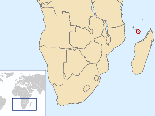
Where is located the Mayotte region ?
Mayotte (also known as Maori) is a French island located in the Indian Ocean in the archipelago of Comoros itself located in the Mozambique Channel. Mayotte consists of two main islands, Grande-Terre and Petite Terre, and several other small islands, Mtsamboro, and Mbouzi Bandrélé. It is an overseas department (DOM) of France. Mamoudzou is the prefecture of Mayotte and the largest city on the island.
What are the statistics and key data of Mayotte ?
The area code of Mayotte is 976. Its inhabitants are called the Mahorais. Mayotte is a french region without districts. Mayote is divided into 19 townships (also called cantons) and 17 towns (also called communes).
Inhabitants of Mayotte were 131 368 in 1997 and 186 452 in 2007.
The area of the region Mayotte is 376,00 km ². The population density of the region Mayotte is 495,88 inhabitants per km².
What are the largest cities of the region of Mayotte ?
The largest cities of the region of Mayotte (compared to the number of inhabitants in 2007) are :
Mamoudzou (976), Koungou (976), Dzaoudzi (976), Dembéni (976), Tsingoni (976), Pamandzi (976), Bandraboua (976), Sada (976), Mtsamboro (976), Bandrélé (976), Chirongui (976), Ouangani (976), Chiconi (976), Bouéni (976), M'tsangamouji (976), Acoua (976), Kani-Kéli (976).
Interactive map of the Mayotte region
You can zoom the satellite map of Mayotte to see a village or a city, for example Mamoudzou.
Search a town of region Mayotte
|
|
|
|
|
|
Records of the Mayotte region: Did you know ?
The town with the longest name of the region of Mayotte is: M'tsangamouji
The town with the shortest name of the region of Mayotte is: Sada
The municipality with the highest altitude of the department region of Mayotte is: Sada with 255 m
The municipality with the lowest altitude of the region of Mayotte is: Pamandzi with 102 m
The municipality with the largest area of the region of Mayotte is: Mamoudzou with 41.94 km ²
The municipality with the smallest area of the region of Mayotte is: Dembéni with 3.88 km ²
|
Towns list of the Mayotte region
Follow the links of towns and cities of the Mayotte region and see photos, maps, and informations for these towns.
|
List of french departments
|
Other regions, departments, maps, hotels and towns in france
Find another town, zip code, department, region, ...
Back to the menus Map of France :
Make a link to this pageTsingoni with the following code :
|
Find a town in France by clicking on the following interactives maps :
|
Map of french regions
|
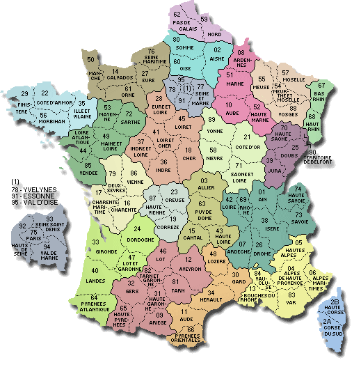
Map of french departments
|
|
Map of France | Regions | Departments | Cities | Partners | Terms | Contact
 French version : Mayotte | Carte de France French version : Mayotte | Carte de France
|