Map of France

Map of France Cities

French version French Version : Villes de France

Find a town, a zip code,
a department, a region... in France
I like Map-France.com !


France Map with cities


Here is the list of the 100 largest cities of France in number of inhabitants in 2006. We do not count here the concept of urban area but only the municipal population.

Click on a city name to view its map, photos, weather and all data.

I like the map of
french cities !
       
  01- Paris
02- Marseille
03- Lyon
04- Toulouse
05- Nice
06- Nantes
07- Strasbourg
08- Montpellier
09- Bordeaux
10- Lille
11- Rennes
12- Reims
13- Le Havre
14- Saint-Étienne
15- Toulon
16- Grenoble
17- Angers
18- Dijon
19- Brest
20- Le Mans
21- Nîmes
22- Aix-en-Provence
23- Clermont-Ferrand
24- Tours
25- Amiens
26- Limoges
27- Villeurbanne
28- Metz
29- Besançon
30- Perpignan
31- Orléans
32- Caen
33- Mulhouse
34- Boulogne-Billancourt
35- Rouen
36- Nancy
37- Argenteuil
38- Montreuil
39- Saint-Denis
40- Roubaix
41- Avignon
42- Tourcoing
43- Poitiers
44- Nanterre
45- Créteil
46- Versailles
47- Pau
48- Courbevoie
49- Vitry-sur-Seine
50- Asnières-sur-Seine
51- Colombes
52- Aulnay-sous-Bois
53- La Rochelle
54- Rueil-Malmaison
55- Antibes
56- Saint-Maur-des-Fossés
57- Calais
58- Champigny-sur-Marne
59- Aubervilliers
60- Béziers
61- Bourges
62- Cannes
63- Saint-Nazaire
64- Dunkerque
65- Quimper
66- Valence
67- Colmar
68- Drancy
69- Mérignac
70- Ajaccio
71- Levallois-Perret
72- Troyes
73- Neuilly-sur-Seine
74- Issy-les-Moulineaux
75- Villeneuve-d'Ascq
76- Noisy-le-Grand
77- Antony
78- Niort
79- Lorient
80- Sarcelles
81- Chambéry
82- Saint-Quentin
83- Pessac
84- Vénissieux
85- Cergy
86- La Seyne-sur-Mer
87- Clichy
88- Beauvais
89- Cholet
90- Hyères
91- Ivry-sur-Seine
92- Montauban
93- Vannes
94- La Roche-sur-Yon
95- Charleville-Mézières
96- Pantin
97- Laval
98- Maisons-Alfort
99- Bondy
100- Évry


Map of metropolitans french cities
Map of France cities

Map of France cities

Search a town, a zip code or a city on this map ...


--------------------------------------------------------------------------


Search Hotels

Book now, best Price Guaranteed !

Where ?


Check-in date
      calendar
Check-out date
      calendar

On 1 January 2011, France had a population of 65,821,885 inhabitants (with all nationalities) for a total area of 675,417 km² (metropolitan and overseas).
Population is distributed as follows:
- 63, 136, 180 live in metropolitan France
- 1,890,705 live in the overseas departments (DOM)
- 795 000 live in communities overseas (COM) (rarely included in most statistics).
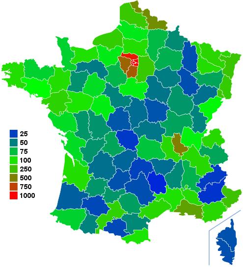
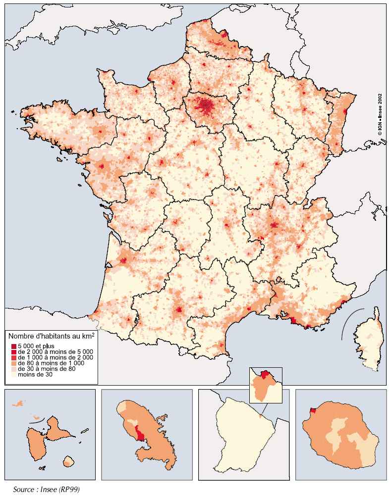
Metropolitan France has a population density of 115 inhabitants per square kilometer and 97 inhabitants / km ² counting the overseas.

In comparison, on January 1 2010, the population of France was estimated at 65 447 374 inhabitants. In this study, population is distributed as follows:
- 62 793 432 in metropolitan France
- 1 873 942 in the overseas departments (DOM)
- 780 000 in communities overseas (COM)

In 2010 the French population is growing by 356 000 compared to 2009. It was an increase of 366 500 persons as compared to 2008.
Northern France is the most populated with about 40 million people (or 2 / 3 of the population) against approximately 22.5 million in the South (or 1 / 3 of the population) (metropolitan France only).
Within the European Union (EU) Demography of France stands out for the life expectancy of women (84.23 years 2008 estimate) which is the highest in Europe and a fertility rate (2.02 in 2008 and 1.99 in 2009) the highest in Europe.

While during the years 1980 and 1990 the demographic growth of metropolitan France was worn mostly by the urban peripheries, now all types of areas are benefiting. In 2006, although the population is still centered around Paris and major cities, some remote areas of cities are becoming denser strongly.
The largest cities of France are in order: the city of Paris, the city of Lyon, the city of Marseille, the city of Lille, the city of Toulouse, the city of Nice, the city of Bordeaux, the city of Nantes, the city of Strasbourg and the city of Toulon.


The 100 largest cities in France

 
Here are the 100 largest cities in France in population in 2006.
Is not counted here the notion of urban area but only the municipal population.

 
01- Paris
02- Marseille
03- Lyon
04- Toulouse
05- Nice
06- Nantes
07- Strasbourg
08- Montpellier
09- Bordeaux
10- Lille
11- Rennes
12- Reims
13- Le Havre
14- Saint-Étienne
15- Toulon
16- Grenoble
17- Angers
18- Dijon
19- Brest
20- Le Mans
21- Nîmes
22- Aix-en-Provence
23- Clermont-Ferrand
24- Tours
25- Amiens
26- Limoges
27- Villeurbanne
28- Metz
29- Besançon
30- Perpignan
31- Orléans
32- Caen
33- Mulhouse
34- Boulogne-Billancourt
35- Rouen
36- Nancy
37- Argenteuil
38- Montreuil
39- Saint-Denis
40- Roubaix
41- Avignon
42- Tourcoing
43- Poitiers
44- Nanterre
45- Créteil
46- Versailles
47- Pau
48- Courbevoie
49- Vitry-sur-Seine
50- Asnières-sur-Seine
51- Colombes
52- Aulnay-sous-Bois
53- La Rochelle
54- Rueil-Malmaison
55- Antibes
56- Saint-Maur-des-Fossés
57- Calais
58- Champigny-sur-Marne
59- Aubervilliers
60- Béziers
61- Bourges
62- Cannes
63- Saint-Nazaire
64- Dunkerque
65- Quimper
66- Valence
67- Colmar
68- Drancy
69- Mérignac
70- Ajaccio
71- Levallois-Perret
72- Troyes
73- Neuilly-sur-Seine
74- Issy-les-Moulineaux
75- Villeneuve-d'Ascq
76- Noisy-le-Grand
77- Antony
78- Niort
79- Lorient
80- Sarcelles
81- Chambéry
82- Saint-Quentin
83- Pessac
84- Vénissieux
85- Cergy
86- La Seyne-sur-Mer
87- Clichy
88- Beauvais
89- Cholet
90- Hyères
91- Ivry-sur-Seine
92- Montauban
93- Vannes
94- La Roche-sur-Yon
95- Charleville-Mézières
96- Pantin
97- Laval
98- Maisons-Alfort
99- Bondy
100- Évry


Urban areas of France

 
Here you will find the map of population density of France, the map of cities of France and finally the detailed classification of the 5 main french areas: Paris, Lyon, Marseille, Lille, Toulouse

The urban area is a concept developed by INSEE to understand and describe the organization of the geographical area of France.
An urban area is defined by INSEE as a continuum formed by an urban center and its suburban ring. When a significant portion of the workforce resident working in another municipality in the urban area, these towns are said "monopolarisées".
This definition was developed between 1994 and 1996 and applied for the first time in the 1999 census, replacing the concept of settlement area and industrial areas (ZPIU) that became too small discriminant.

Here are the top 5 French main areas:


# Name of the urban area Number of towns Population (1999) Area in km² (1999) Density inhab/km² (1999) Name of the urban area Population (2006) Area in km² (2006) Densityinhab/km² (2006)
1 Paris 1 584 11 174 743 14 549 768 Grand bassin parisien 11 769 433 14 549 809
2 Lyon 296 1 648 216 3 356 491 Rhône et Alpes 1 748 271 3 356 521
3 Marseille-Aix-en-Provence 82 1 516 340 2 832 535 Grand delta méditerranéen 1 601 095 2 832 565
4 Lille-Roubaix-Tourcoing 130 1 143 125 975 1 173 Nord-Pas-de-Calais 1 164 716 975 1 195
5 Toulouse 342 964 797 4 015 240 Toulouse 1 102 887 4 015 275


Map OF FRANCE - URBAN AREA
MAP OF FRANCE URBAN AREA
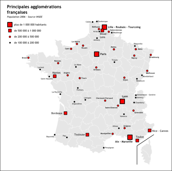
MAP OF FRANCE CITIES


Population density

 
As regards the whole of France, metropolitan as overseas population density is 97 inhabitants / km ² in 2010. The population density in France is 115 inhabitants / km ² in 2010. Population density increases sharply in the city. It can reach more than 2000 per km ² in the center of cities. But today the population of rural areas grows at the same rate as that of the whole territory of France (+0.7% per year).

 
  Map of France - Population density per department   Map of France - Population distribution  
  Map of France population density
Map of France - Population density
  Map of France Population distribution
Map of France - Population distribution


Map of France | Regions | Departments | Cities | Partners | Terms | Contact

French version French version :  Villes françaises | Carte de France