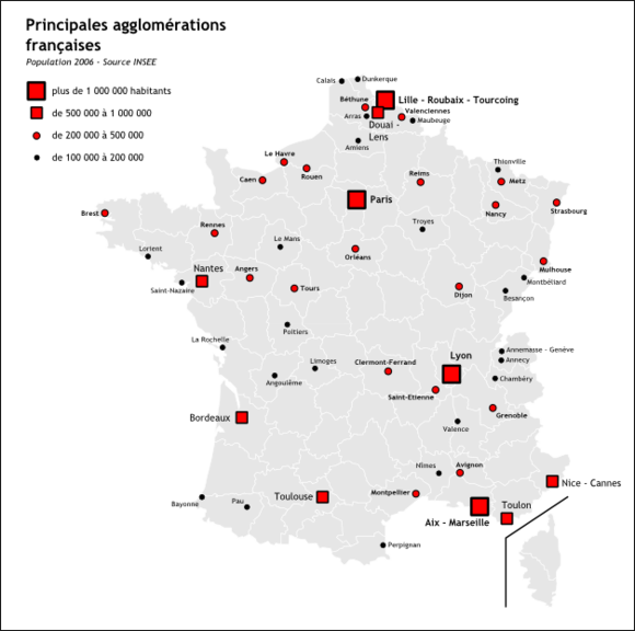
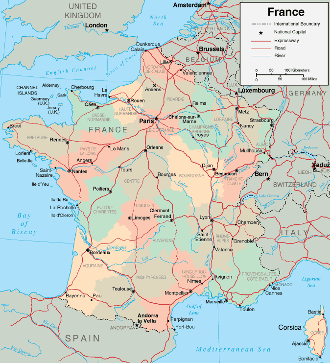
Map of France

Map of France

French version French Version : Carte de France

Find a town, a zip code,
a department, a region... in France
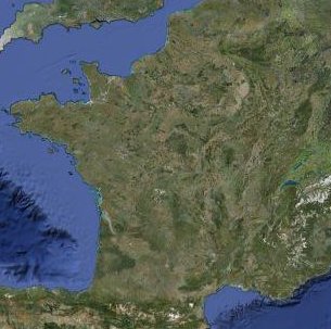
I like Map-France.com !


Map of France

Search a town, a zip code, a department, a region in France...
And find informations, maps, hotels, weather forecast, pictures,... on every french town !
 
I like
Map of France !


Find all your information on a map of France with Map-France.com:
  -  map of France with regions and departments
  -  map of France with cities and towns
  -  the road map of France with driving directions
  -  the satellite map of France
  -  the weather forecast map of France
  -  all maps and data on every french town
With Map-France.com search and find maps, hotels, weather forecast, pictures, statistics and all data you need on every french town !


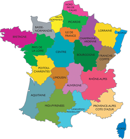
Map of france departments

 
01 - Ain - Bourg-en-Bresse
02 - Aisne - Laon
03 - Allier - Moulins
04 - Alpes-de-Haute-Provence - Digne
05 - Hautes-Alpes - Gap
06 - Alpes Maritimes - Nice
07 - Ardèche - Privas
08 - Ardennes - Charleville-Mézières
09 - Ariège - Foix
10 - Aube - Troyes
11 - Aude - Carcassonne
12 - Aveyron - Rodez
13 - Bouches-du-Rhône - Marseille
14 - Calvados - Caen
15 - Cantal - Aurillac
16 - Charente - Angoulême
17 - Charente-Maritime - La Rochelle
18 - Cher - Bourges
19 - Corrèze - Tulle
2A - Corse-du-Sud - Ajaccio
2B - Haute Corse - Bastia
21 - Côte-d'Or - Dijon
22 - Côtes d'Armor - St-Brieuc
23 - Creuse - Guéret
24 - Dordogne - Périgueux
25 - Doubs - Besançon
26 - Drôme - Valence
27 - Eure - Evreux
28 - Eure-et-Loir - Chartres
29 - Finistère - Quimper
30 - Gard - Nîmes
31 - Haute Garonne - Toulouse
32 - Gers - Auch
33 - Gironde - Bordeaux
34 - Hérault - Montpellier
35 - Ille-et-Vilaine - Rennes
36 - Indre - Châteauroux
37 - Indre-et-Loire - Tours
38 - Isère - Grenoble
39 - Jura - Lons-le-Saunier
40 - Landes - Mont-de-Marsan
41 - Loir-et-Cher - Blois
42 - Loire - St-Étienne
43 - Haute Loire - Le Puy
44 - Loire Atlantique - Nantes
45 - Loiret - Orléans
46 - Lot - Cahors
47 - Lot-et-Garonne - Agen
48 - Lozère - Mende
49 - Maine-et-Loire - Angers
50 - Manche - St-Lô
51 - Marne - Châlons-sur-Marne
52 - Haute Marne - Chaumont
53 - Mayenne - Laval
54 - Meurthe-et-Moselle - Nancy
55 - Meuse - Bar-le-Duc
56 - Morbihan - Vannes
57 - Moselle - Metz
58 - Nièvre - Nevers
59 - Nord - Lille
60 - Oise - Beauvais
61 - Orne - Alençon
62 - Pas-de-Calais - Arras
63 - Puy-de-Dôme - Clermont-Ferrand
64 - Pyrénées Atlantiques - Pau
65 - Hautes Pyrénées - Tarbes
66 - Pyrénées Orientales - Perpignan
67 - Bas-Rhin - Strasbourg
68 - Haut-Rhin - Colmar
69 - Rhône - Lyon
70 - Haute Saône - Vesoul
71 - Saône-et-Loire - Mâcon
72 - Sarthe - Le Mans
73 - Savoie - Chambéry
74 - Haute Savoie - Annecy
75 - Paris - Paris
76 - Seine Maritime - Rouen
77 - Seine-et-Marne - Melun
78 - Yvelines - Versailles
79 - Deux-Sèvres - Niort
80 - Somme - Amiens
81 - Tarn - Albi
82 - Tarn-et-Garonne - Montauban
83 - Var - Toulon
84 - Vaucluse - Avignon
85 - Vendée - La Roche-sur-Yon
86 - Vienne - Poitiers
87 - Haute Vienne - Limoges
88 - Vosges - Épinal
89 - Yonne - Auxerre
90 - Territoire de Belfort - Belfort
91 - Essonne - Evry
92 - Hauts-de-Seine - Nanterre
93 - Seine-St-Denis - Bobigny
94 - Val-de-Marne - Créteil
95 - Val-D'Oise - Pontoise
971 - Guadeloupe - Basse-Terre
972 - Martinique - Fort-de-France
973 - Guyane - Cayenne
974 - La Reunion - Saint-Denis
976 - Mayotte - Mamoudzou
  The department is the second level of administrative divisions on the map of France. This division into departments is between the region and the district ("arrondissement").

Each department belongs to a single region. (Each of four overseas region being composed of a single department).

France is divided into 101 departments. They are divided into 343 districts ("arrondissements"), 4 058 townships ("cantons") and 36 699 Towns ("communes").

Each department has a capital city or prefecture which includes its institutions. This capital is often the largest city of the department.

According to figures (in 1999), the median population of a department of continental France was 511 012 inhabitants.

The skills of the department are:
- Social Action
- Restructure rural land
- Construction
- Maintenance of colleges
- School and transport
- ...

The removal of one or more local levels is being debated in France for several years and especially the option to remove department level.
For now, the Balladur committee dealing with the reform of local government did not adopt this proposal, so there is currently no change at the departmental level.

At right, you will find the map of French departments.
Clicking on a department link, You will find a detailed map of the department and statistical informations, photos, travel guide for all cities of this department.
 
Map of France - Department
Map of France department
MAP OF FRANCE DEPARTEMENT


Map of France regions

 
Alsace
Aquitaine
Auvergne
BasseNormandie
Bourgogne
Bretagne
Centre
Champagne-Ardenne
Corse
Franche-Comté
HauteNormandie
Ile-de-France
Languedoc-Roussillon
Limousin
Lorraine
MidiPyrénées
Nord-Pas-de-Calais
Pays de la Loire
Picardie
Poitou-Charentes
Provence-Alpes-Côte-d'Azur
RhôneAlpes

Overseas regions :

Guadeloupe
Martinique
Guyane
La Réunion
Mayotte
 
The region is the first level of administrative divisions on the map of France.

Before the French Revolution of 1789, France was divided into provinces from the historical feudal history. Some of these regions roughly correspond to the current regions.
During the revolution these provinces were abolished and the French territory was divided into 83 departments.

On 5 April 1919, the first ministerial decree establishes the first regional grouping called "regions Clémentel".
From the First World War, the development of transport, urban, building regionalist ideas, leading some to question the desirability of creating larger administrative divisions than departments.

Skills in the region include:
- Territory development
- Economic development
- Vocational training
- Constructions
- Maintenance of schools
- Rail transport
- ...

The first election of Regional Councillors by universal suffrage was in March 16, 1986. Regions became officialy french divisions as departments and municipalities.

France is divided into 27 regions, which in turn are divided into 101 departments, 343 districts ("arrondissements"), 4 058 townships ("cantons") and 36 699 Towns ("communes").


At right, you could find the map of France regions. Clicking on a region link, you will find a detailed map of the region and statistical informations, photos, travel guide for all cities of this region.


Map of France - Regions
Map of France Regions
MAP FRANCE REGION


Map of France cities

Here are the 100 largest cities of France (population 2006). We do not count here the concept of urban area but the municipal population.
Click on the city name to see all this information: pictures, maps, population, population density, area, elevation, geographic coordinates, ...


In 2010, the population of France was estimated at 65 447 374 inhabitants. On 1 January 2009, the population of France was estimated at 65 073 482 inhabitants, distributed as follows:
- 62 448 977 in metropolitan France
- 1 854 505 in the overseas departments (DOM without St. Martin and St. Barthelemy)
- 770 000 in overseas communities (COM, including St. Martin and St. Barthelemy)


The population is increasing by 366 500 people by 2008.
Northern France is the most populated with about 40 million people (or 2 / 3 of the population) against approximately 22.5 million in the South (or 1 / 3 of the population) (metropolitan France only).
Within the European Union (EU) demography of France stands out for the life expectancy of women (84.23 years 2008 estimate) which is the highest in Europe and a fertility rate (2.02 in 2008) the highest in Europe.


At right, you could find the map of France's largest cities. By browsing the site you can view a map of France, statistics, informations, photos and travel guide for each town of France.


You will find here (clicking on this map at right), the map of population density of France, the map of cities of France and finally the detailed classification of the 5 main areas French: Paris, Lyon, Marseille, Lille, Toulouse


Map of France - Cities
Map of France cities
MAP FRANCE CITIES


Map of France : key data

  Administrative divisions : France is divided into 27 regions, 101 departments, 343 districts (arrondissements), 4 058 townships (cantons) and 36 699 Towns (communes).
Population of France : In 2010, the population of France was estimated at 65 447 374 inhabitants.
Largest cities of France : The 5 largest cities of France are (municipal population in 2006) : 1-Paris, 2-Marseille, 3-Lyon, 4-Toulouse, 5-Nice
Largest urban areas of France : The 5 largest urban areas of France are (population of urban areas in 2006) : 1-Paris, 2-Lyon, 3-Marseille, 4-Lille, 5-Toulouse
The mountains on the map of France : The 5 major mountains of France are the Alpes, the Pyrénnées, the Massif Central, the Jura, the Vosges
The seas on the map of France : The 4 seas around France are: the North Sea, the English Channel, the Atlantic Ocean, the mediterranean sea
The rivers on the map of France : The 5 main rivers of France are: the Seine, the Loire, the Garonne, the Rhone, the Rhine
The highest mountain in France : The highest point on the map of France is the Mont Blanc in the Alpes, peaking at 4 810.45 m.
 
 
MAP OF FRANCE
map of france
map of france


Map of France | Regions | Departments | Cities | Partners | Terms | Contact

French version French version :  Carte de France