Map of France

Allier
Department 03

French version French Version : Allier

Find a town, a zip code,
a department, a region... in France
I like Map-France.com !


Department of Allier - 03


Department of Allier

The department is the second level of administrative divisions on the map of France. 
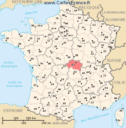
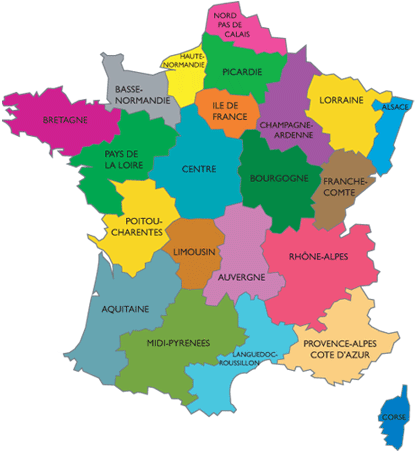
The department of Allier is located in the region of region of Auvergne.

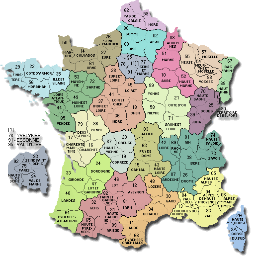
The department of Allier has the number 03 and is divided into 3 districts , 35 townships and 320 municipalities. Below you will find the localization of Allier on the map of France, and the satellite map of Allier.


Population of Allier

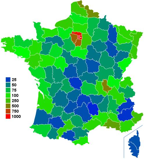
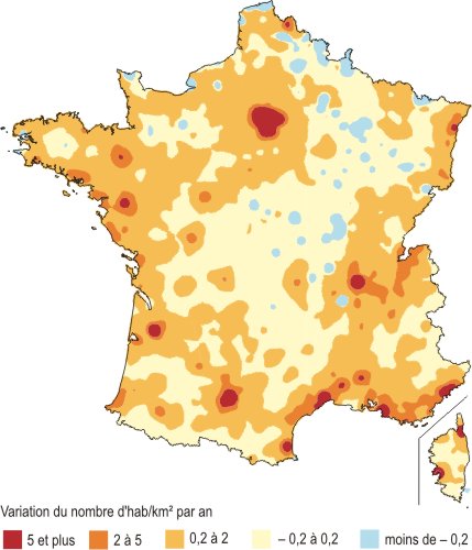
Inhabitants of Allier were 344 721 in the 1999 census and 343 309 in the 2006 census. Area of departement of Allier is 7 340,11 km ². Population density of Allier is 46,77 inhabitants per km².

Biggest cities of department of Allier, in number of inhabitants, are (2007 census): Montluçon, Vichy, Moulins, Cusset, Yzeure, Domérat, Bellerive-sur-Allier, Commentry, Gannat, Saint-Pourçain-sur-Sioule, Désertines, Avermes, Varennes-sur-Allier, Saint-Germain-des-Fossés, Dompierre-sur-Besbre, Lapalisse, Creuzier-le-Vieux, Saint-Yorre.

You will find the towns list of Allier in the bottom on this page. You can consult the map of France, pictures, hotels, and all data of every town and village in the department of Allier clicking on these towns links.


I like the department of
Allier !
   
Biggest cities of Allier
Name of biggest cities
of Allier


Census
(2007)


Area
(km ²)


Density
(inh/km²)


Altitude
(m)


Montluçon39 76120.671 923.61207 m
Vichy25 4675.854 353.33268 m
Moulins20 2518.612 352.03219 m
Cusset13 35831.93418.35271 m
Yzeure12 47043.24288.39240 m
Domérat9 00035.54253.24240 m
Bellerive-sur-Allier8 61718.97454.24277 m
Commentry6 80320.96324.57376 m
Gannat5 88136.85159.59341 m
Saint-Pourçain-sur-Sioule5 04535.67141.44250 m
Désertines4 4658.34535.37240 m
Avermes3 82715.60245.32219 m
Varennes-sur-Allier3 81424.10158.26240 m
Saint-Germain-des-Fossés3 6728.30442.41245 m
Dompierre-sur-Besbre3 29345.6372.17221 m
Lapalisse3 19633.0196.82280 m
Creuzier-le-Vieux3 19511.38280.76363 m
Saint-Yorre2 7346.35430.55280 m
Statistics of department of Allier
Population 1999 344 721 inhabitants  
Population 2006 343 309 inhabitants  
Area 7 340.11 km ²  
Population density 46.77 inhabs/km² Map France population density
Variation of density -0.06 %/year Map France population variation density
     
Administration of department of Allier
Number 03  
Prefecture Moulins  
Subprefectures Montluçon
Vichy
Map of France cities
Region Auvergne (83) Map of France regions
     
Subdivisions of the department of Allier
Districts 3  
Townships 35  
Municipalities 320  


Hotel Allier

Search hotels of Allier : Book your hotel now !

Where ? 

Check-in date 
calendar
Check-out date 
calendar


Book now ! Best Price Guaranteed, no booking fees, pay at the hotel with our partner Booking.com, leader in online hotel reservation.
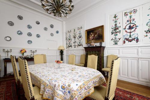
 
Appartement à coté de l’hôpital et du centre ville : Hotel near Allier
Hotel Montluçon
Appartement à coté de l’hôpital et du centre ville

Rate : from 0.00 € to 0.00 €
Address : 10 bis avenue du 8 Mai 1945 03100 Montluçon
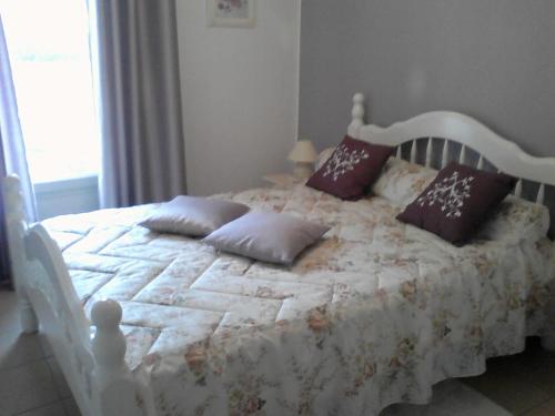
Le Grenier à Sel : Hotel near Allier
Hotel Montluçon
Le Grenier à Sel
Offering a restaurant, Le Grenier à Sel is located in Montluçon. Free WiFi access is available. This property is 8 km from Néris-les-Bains Spa. Each room features air conditioning, a ...
Price : from 154.00 € to 154.00 €
Contact : 10, rue Sainte Anne 03100 Montluçon
La Demeure de Babette : Hotel near Allier
Hotel Moulins
La Demeure de Babette
Situated in Moulins, 300 metres from Moulins Cathedral and 2.6 km from Centre national du costume de scène, La Demeure de Babette provides accommodation with free WiFi and a garden. The...
Prices : from 98.00 € to 98.00 €
Contact : 24 Rue Des Potiers 03000 Moulins
60's corner : Hotel near Allier
Hotel Moulins
60's corner
60's corner offers accommodation in Moulins, 500 metres from Moulins Cathedral and 1.6 km from Centre national du costume de scène. 60's corner boasts views of the city and is 1 km from ...
Rate : from 65.00 € to 65.00 €
Contact : 67 Rue des Potiers 03000 Moulins
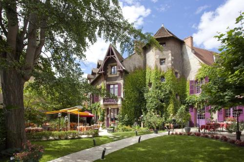
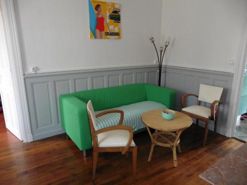
Résidence Eugénie : Hotel near Allier
Hotel Vichy
Résidence Eugénie
Résidence Eugénie is a self-catering accommodation located in Vichy, 800 metres from Vichy Palais des Congres. The 2-bedroom apartment features a balcony and a flat-screen TV. The flea ...
Price : from 0.00 € to 0.00 €
Address : 9 rue du Champ de foire 03200 Vichy
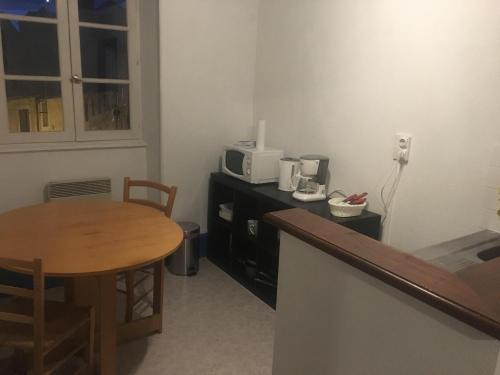
appart vichy : Hotel near Allier
Hotel Vichy
appart vichy
Situated in Vichy, just 800 metres from Vichy thermal baths, appart vichy features accommodation with free WiFi. Guests staying at this apartment have access to a fully equipped kitchen. ...
Prices : from 60.00 € to 60.00 €
Contact : 22 Rue Paul Bert - Mr decarpentrie frederic 03200 Vichy


Map of Allier

MAP OF THE ALLIER DEPARTMENT
map department Allier

Where is located the Allier department ?
The department of Allier is located in the region of Auvergne. Allier is in red on the map of french departments.

What are the statistics and key data of Allier ?
The department of Allier has the number 03. It is composed of 3 districts ("arrondissements") , 35 townships ("cantons") and 320 towns ("communes").
The 3 districts of the department of Allier are : Montluçon, Moulins, Vichy.
The inhabitants of of Allier were 344 721 in 1999 and 343 309 in 2006. The area of the department of Allier is 7 340,11 km ². Population density of the department of Allier is 46,77 inhabitants per km².


What are the largest cities of the department of Allier ?
The largest cities of the department of Allier (compared to the number of inhabitants in 2007) are : Montluçon, Vichy, Moulins, Cusset, Yzeure, Domérat, Bellerive-sur-Allier, Commentry, Gannat, Saint-Pourçain-sur-Sioule, Désertines, Avermes, Varennes-sur-Allier, Saint-Germain-des-Fossés, Dompierre-sur-Besbre, Lapalisse, Creuzier-le-Vieux, Saint-Yorre.

Interactive map of the Allier department
You can zoom the satellite map of Allier to see a village or a city, for example Moulins.

Search a town of departement of Allier


Records of the Allier department: Did you know ?


The town with the longest name of the department of Allier is: Saint-Pourçain-sur-Besbre
The town with the shortest name of the department of Allier is: Bert
The municipality with the highest altitude of the department of Allier is: Saint-Nicolas-des-Biefs with 882 m
The municipality with the lowest altitude of the department of Allier is: Urçay with 168 m
The municipality with the largest area of the department of Allier is: Lurcy-Lévis with 71.42 km ²
The municipality with the smallest area of the department of Allier is: Le Montet with 1.77 km ²


Towns list of the Allier department

Follow the links of towns and cities of the Allier department and see photos, maps, and informations for these towns.


Towns of department of Allier in A
AbrestAgongesAinay-le-ChâteauAndelaroche
ArchignatArfeuillesArpheuilles-Saint-PriestArronnes
AubignyAudesAurouërAutry-Issards
AvermesAvrilly


Towns of department of Allier in B
BagneuxBarberierBarrais-BussollesBayet
BeaulonBeaune-d'AllierBèguesBellenaves
Bellerive-sur-AllierBertBessay-sur-AllierBesson
BézenetBillezoisBillyBiozat
BizeneuilleBlomardBostBoucé
Bourbon-l'ArchambaultBraizeBransatBresnay
BressollesBroût-VernetBrugheasBusset
Buxières-les-Mines


Towns of department of Allier in C
CérillyCessetChambératChamblet
ChantelleChapeauChappesChareil-Cintrat
CharmeilCharmesCharrouxChassenard
Château-sur-AllierChâtel-de-NeuvreChâtel-MontagneChâtelperron
ChâtelusChâtillonChavenonChavroches
ChazemaisChemillyChevagnesChezelle
ChézyChirat-l'ÉgliseChouvignyCindré
Cognat-LyonneColombierCommentryContigny
Cosne-d'AllierCoulandonCoulangesCouleuvre
CourçaisCoutansouzeCouzonCréchy
CressangesCreuzier-le-NeufCreuzier-le-VieuxCusset


Towns of department of Allier in D
Deneuille-lès-ChantelleDeneuille-les-MinesDésertinesDeux-Chaises
DiouDomératDompierre-sur-BesbreDoyet
DroiturierDurdat-Larequille


Towns of department of Allier in E
ÉbreuilÉchassièresEscurollesEspinasse-Vozelle
EstivareillesÉtroussat


Towns of department of Allier in F
Ferrières-sur-SichonFleurielFourillesFranchesse


Towns of department of Allier in G
GannatGannay-sur-LoireGarnat-sur-EngièvreGennetines
GipcyGivarlaisGouise


Towns of department of Allier in H
HauteriveHérissonHurielHyds


Towns of department of Allier in I
Isle-et-BardaisIsserpent


Towns of department of Allier in J
Jaligny-sur-BesbreJenzat


Towns of department of Allier in L
La CelleLa ChabanneLa ChapelaudeLa Chapelle
La Chapelle-aux-ChassesLa Ferté-HauteriveLa GuillermieLa Petite-Marche
LafélineLalizolleLamaidsLangy
LapalisseLaprugneLavault-Sainte-AnneLavoine
Le BouchaudLe BrethonLe BreuilLe Donjon
Le Mayet-d'ÉcoleLe Mayet-de-MontagneLe MontetLe Pin
Le TheilLe VernetLe VeurdreLe Vilhain
LenaxLételonLiernollesLignerolles
LimoiseLoddesLorigesLouchy-Montfand
Louroux-BourbonnaisLouroux-de-BeauneLouroux-de-BoubleLouroux-Hodement
LuneauLurcy-LévisLusigny


Towns of department of Allier in M
MagnetMailletMalicorneMarcenat
Marcillat-en-CombrailleMarignyMariolMazerier
MaziratMeaulneMeillardMeillers
MercyMesplesMolinetMolles
MonestierMonétay-sur-AllierMonétay-sur-LoireMontaigu-le-Blin
Montaiguët-en-ForezMontbeugnyMontcombroux-les-MinesMonteignet-sur-l'Andelot
MontillyMontluçonMontmaraultMontoldre
MontordMontvicqMoulinsMurat


Towns of department of Allier in N
NadesNassignyNavesNéris-les-Bains
Neuilly-en-DonjonNeuilly-le-RéalNeureNeuvy
NizerollesNoyant-d'Allier


Towns of department of Allier in P
Paray-le-FrésilParay-sous-BriaillesPérignyPierrefitte-sur-Loire
PoëzatPouzy-MésangyPrémilhat


Towns of department of Allier in Q
Quinssaines


Towns of department of Allier in R
ReugnyRoclesRongèresRonnet


Towns of department of Allier in S
Saint-AngelSaint-Aubin-le-MonialSaint-Bonnet-de-FourSaint-Bonnet-de-Rochefort
Saint-Bonnet-TronçaisSaint-CapraisSaint-ChristopheSaint-Clément
Saint-DésiréSaint-Didier-en-DonjonSaint-Didier-la-ForêtSaint-Éloy-d'Allier
Saint-EnnemondSaint-Étienne-de-VicqSaint-FargeolSaint-Félix
Saint-GenestSaint-Gérand-de-VauxSaint-Gérand-le-PuySaint-Germain-de-Salles
Saint-Germain-des-FossésSaint-HilaireSaint-Léger-sur-VouzanceSaint-Léon
Saint-Léopardin-d'AugySaint-LoupSaint-Marcel-en-MarcillatSaint-Marcel-en-Murat
Saint-Martin-des-LaisSaint-MartinienSaint-MenouxSaint-Nicolas-des-Biefs
Saint-PalaisSaint-Pierre-LavalSaint-PlaisirSaint-Pont
Saint-Pourçain-sur-BesbreSaint-Pourçain-sur-SiouleSaint-Priest-d'AndelotSaint-Priest-en-Murat
Saint-PrixSaint-Rémy-en-RollatSaint-SauvierSaint-Sornin
Saint-VictorSaint-VoirSaint-YorreSainte-Thérence
Saligny-sur-RoudonSanssatSaulcetSaulzet
SauvagnySazeretSerbannesServilly
SeuilletSorbierSouvignySussat


Towns of department of Allier in T
TargetTaxat-SenatTeillet-ArgentyTerjat
TheneuilleThiel-sur-AcolinThionneTortezais
Toulon-sur-AllierTrebanTreignatTreteau
TrévolTrézellesTronget


Towns of department of Allier in U
UrçayUssel-d'Allier


Towns of department of Allier in V
ValignatValignyVallon-en-SullyVarennes-sur-Allier
Varennes-sur-TècheVaumasVauxVeauce
VenasVendatVerneixVerneuil-en-Bourbonnais
VernusseVichyVicqVieure
VillebretVillefranche-d'AllierVilleneuve-sur-AllierViplaix
VitrayVoussac


Towns of department of Allier in Y
YgrandeYzeure


List of french departments


Ain
Aisne
Allier
Alpes de Haute-Provence
Hautes-Alpes
Alpes Maritimes
Ardèche
Ardennes
Ariège
Aube
Aude
Aveyron
Bouches-du-Rhône
Calvados
Cantal
Charente
Charente-Maritime
Cher
Corrèze
Corse-du-Sud
HauteCorse
Côte-d'Or
Côtes d'Armor
Creuse
Dordogne

Doubs
Drôme
Eure
Eure-et-Loir
Finistère
Gard
Haute Garonne
Gers
Gironde
Hérault
Ille-et-Vilaine
Indre
Indre-et-Loire
Isère
Jura
Landes
Loir-et-Cher
Loire
Haute Loire
Loire Atlantique
Loiret
Lot
Lot-et-Garonne
Lozère
Maine-et-Loire

Manche
Marne
HauteMarne
Mayenne
Meurthe-et-Moselle
Meuse
Morbihan
Moselle
Nièvre
Nord
Oise
Orne
Pas-de-Calais
Puy-de-Dôme
Pyrénées Atlantiques
Hautes Pyrénées
Pyrénées Orientales
Bas-Rhin
Haut-Rhin
Rhône
Haute Saône
Saône-et-Loire
Sarthe
Savoie
Haute Savoie

Paris
Seine Maritime
Seine-et-Marne
Yvelines
Deux-Sèvres
Somme
Tarn
Tarn-et-Garonne
Var
Vaucluse
Vendée
Vienne
Haute Vienne
Vosges
Yonne
Territoire de Belfort
Essonne
Hauts-de-Seine
Seine-St-Denis
Val-de-Marne
Val-D'Oise
Guadeloupe
Martinique
Guyane
La-Reunion
Mayotte


Other departments, regions, maps, hotels and towns in france


Find another town, zip code, department, region, ...


Back to the menus Map of France :


Make a link to this pageYzeure with the following code :


Find a town in France by clicking on the following interactives maps :


MAP OF FRANCE REGION


Map of french regions


Map of french regions Alsace Lorraine Franche Comte Champagne Ardenne Nord pas de Calais Picardie Haute Normandie Basse Normandie Bretagne Pays de la Loire Poitou Charentes Limousin Centre Ile de France Bourgogne Rhone Alpes Auvergne Provence Midi Pyrenees Aquitaine Languedoc Rousillon Corse

MAP OF FRANCE DEPARTMENT


Map of french departments
Map of french departments Map France department Nord 59 [15] Map France department Pas de Calais 62 [15] Map France department Somme 80 [19] Map France department Aisne 02 [19] Map France department Oise 60 [19] Map France department Seine Maritime 76 [17] Map France department Eure 27 [17] Map France department Ardennes 08 [07] Map France department Marne 51 [07] Map France department Aube 10 [07] Map France department Haute Marne 52 [07] Map France department Meuse 55 [13] Map France department Meurthe et Moselle 54 [13] Map France department Moselle 57 [13] Map France department Vosges 88 [13] Map France department Bas Rhin 67 [01] Map France department Haut Rhin 68 [01] Map France department Territoire de Belfort 90 [09] Map France department Haute Saône 70 [09] Map France department Doubs 25 [09] Map France department Jura 39 [09] Map France department Haute Savoie 74 [22] Map France department Ain 01 [22] Map France department Rhône 69 [22] Map France department Loire 42 [22] Map France department Savoie 73 [22] Map France department Isère 38 [22] Map France department Drôme 26 [22] Map France department Ardèche 07 [22] Map France department Hautes Alpes 05 [21] Map France department Alpes de Haute Provence 04 [21] Map France department Alpes Maritimes 06 [21] Map France department Var 83 [21] Map France department Vaucluse 84 [21] Map France department Bouches du Rhône 13 [21] Map France department Haute Corse 2B [08] Map France department Corse du Sud 2A [08] Map France department Yonne 89 [04] Map France department Côte d'Or 21 [04] Map France department Saône et Loire 71 [04] Map France department Nièvre 58 [04] Map France department Calvados 14 [16] Map France department Manche 50 [16] Map France department Orne 61 [16] Map France department Eure et Loir [06] Map France department Loiret 45 [06] Map France department Loir et Cher 41 [06] Map France department Cher 18 [06] Map France department Indre et Loire 37 [06] Map France department Indre 36 [06] Map France department Allier 03 [03] Map France department Puy de Dôme 63 [03] Map France department Haute Loire 43 [03] Map France department Cantal 15 [03] Map France department Finistère 29 [05] Map France department Côtes d'Armor 22 [05] Map France department Ille et Vilaine 35 [05] Map France department Morbihan 56 [05] Map France department Mayenne 53 [18] Map France department Sarthe 72 [18] Map France department Maine et Loire 49 [18] Map France department Loire Atlantique 44 [18] Map France department Vendée 85 [18] Map France department Deux sèvres 79 [20] Map France department Vienne 86 [20] Map France department Charente Maritime 17 [20] Map France department Charente 16 [20] Map France department Creuse 23 [12] Map France department Haute Vienne 87 [12] Map France department Corrèze 19 [12] Map France department Dordogne 24 [02] Map France department Gironde 33 [02] Map France department Lot et Garonne 47 [02] Map France department Landes 40 [02] Map France department Pyrénées Athlantiques 64 [02] Map France department Lot 46 [14] Map France department Aveyron 12 [14] Map France department Tarn 81 [14] Map France department Tarn et Garonne 82 [14] Map France department Gers 32 [14] Map France department Haute Garonne 31 [14] Map France department Hautes Pyrénées 65 [14] Map France department Ariège 09 [14] Map France department Lozère 48 [11] Map France department Gard 30 [11] Map France department Hérault 34 [11] Map France department Aude 11 [11] Map France department Pyrénées Orientales 66 [11] Map France department Seine et Marne 77 [10] Map France department Essonne 91 [10] Map France department Yvelines 78 [10] Map France department Val d'Oise 95 [10]


Map of France | Regions | Departments | Cities | Partners | Terms | Contact

French version French version :  Allier | Carte de France