Map of France

Corse-du-Sud
Department 2A

French version French Version : Corse-du-Sud

Find a town, a zip code,
a department, a region... in France
I like Map-France.com !


Department of Corse-du-Sud - 2A


Department of Corse-du-Sud

The department is the second level of administrative divisions on the map of France. The department of Corse-du-Sud is located in the region of region of Corse.

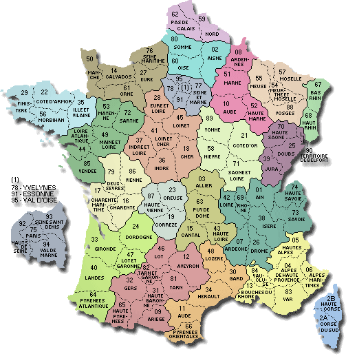
The department of Corse-du-Sud has the number 2A and is divided into 2 districts , 22 townships and 124 municipalities. Below you will find the localization of Corse-du-Sud on the map of France, and the satellite map of Corse-du-Sud.


Population of Corse-du-Sud

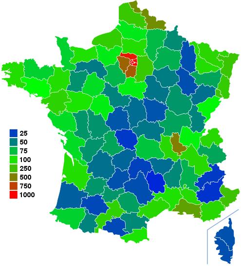
Inhabitants of Corse-du-Sud were 118 593 in the 1999 census and 135 718 in the 2006 census. Area of departement of Corse-du-Sud is 4 014,22 km ². Population density of Corse-du-Sud is 33,81 inhabitants per km².

Biggest cities of department of Corse-du-Sud, in number of inhabitants, are (2007 census): Ajaccio, Porto-Vecchio, Propriano, Bastelicaccia, Sartène, Alata, Bonifacio, Afa, Grosseto-Prugna, Zonza, Sarrola-Carcopino, Cuttoli-Corticchiato, Peri, Albitreccia, Appietto, Cauro, Pietrosella, Olmeto.

You will find the towns list of Corse-du-Sud in the bottom on this page. You can consult the map of France, pictures, hotels, and all data of every town and village in the department of Corse-du-Sud clicking on these towns links.


I like the department of
Corse-du-Sud !
   
Biggest cities of Corse-du-Sud
Name of biggest cities
of Corse-du-Sud


Census
(2007)


Area
(km ²)


Density
(inh/km²)


Altitude
(m)


Ajaccio64 43282.03785.4720 m
Porto-Vecchio11 326168.6567.1660 m
Propriano3 24318.73173.1420 m
Bastelicaccia3 18518.21174.90448 m
Sartène3 055200.4015.24320 m
Alata2 96230.3797.53437 m
Bonifacio2 852138.3620.6130 m
Afa2 65511.84224.24140 m
Grosseto-Prugna2 59431.5682.19600 m
Zonza2 179134.4616.21760 m
Sarrola-Carcopino1 86127.0168.90400 m
Cuttoli-Corticchiato1 81930.3759.89553 m
Peri1 51623.6564.10440 m
Albitreccia1 37945.7630.145 m
Appietto1 32234.4138.42460 m
Cauro1 26427.9045.30356 m
Pietrosella1 22335.2334.71540 m
Olmeto1 19943.8227.36340 m
Statistics of department of Corse-du-Sud
Population 1999 118 593 inhabitants  
Population 2006 135 718 inhabitants  
Area 4 014.22 km ²  
Population density 33.81 inhabs/km² Map France population density
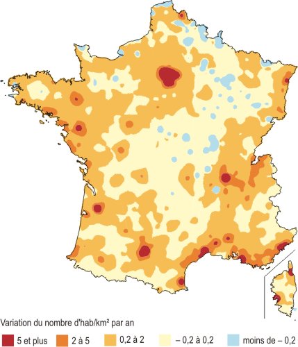
Variation of density +1.95 %/year Map France population variation density
     
Administration of department of Corse-du-Sud
Number 2A  
Prefecture Ajaccio  
Subprefectures Sartène Map of France cities
Region Corse (94) Map of France regions
     
Subdivisions of the department of Corse-du-Sud
Districts 2  
Townships 22  
Municipalities 124  


Hotel Corse-du-Sud

Search hotels of Corse-du-Sud : Book your hotel now !

Where ? 

Check-in date 
calendar
Check-out date 
calendar


Book now ! Best Price Guaranteed, no booking fees, pay at the hotel with our partner Booking.com, leader in online hotel reservation.
 
Napoleon : Hotel near Corse-du-Sud
Hotel Ajaccio
Napoleon
 Preferred hotel ! 
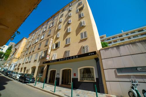
For guests interested in sight-seeing or business travel, Hotel Napoleon is ideally located in the centre of Ajaccio, a few steps away from congress meeting place and close to the beaches...
Rate : from 69.00 € to 103.00 €
Address : 4 Rue Lorenzo-Vero 20000 Ajaccio
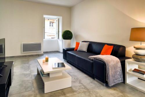
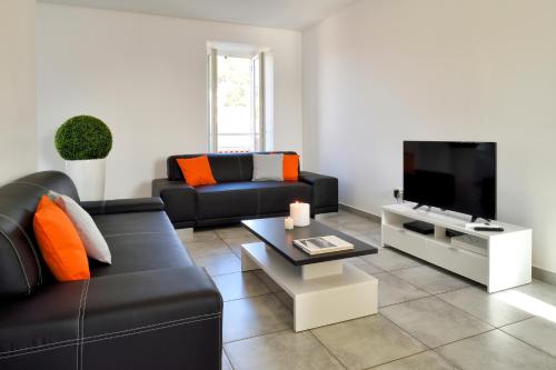
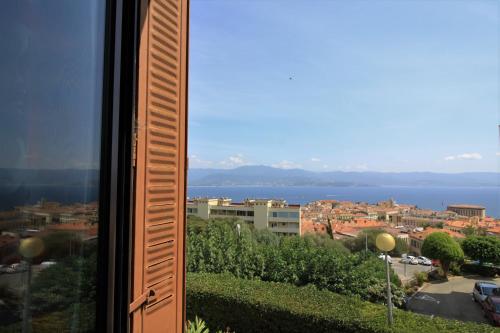
Appartement Ajaccio Vue mer : Hotel near Corse-du-Sud
Hotel Ajaccio
Appartement Ajaccio Vue mer
Appartement Ajaccio Vue mer is situated in Ajaccio, 1.7 km from Port des Cannes, in an area where snorkelling can be enjoyed. This apartment is 12 km from Sanguinaires Islands. The apart...
Price : from 0.00 € to 0.00 €
Contact : 23 Avenue Imperatrice Eugenie 20000 Ajaccio
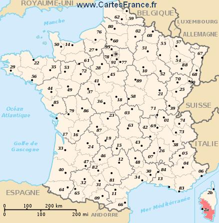
T3 neuf d'exception meublé de tourisme 4 * : Hotel near Corse-du-Sud
Hotel Sartène
T3 neuf d'exception meublé de tourisme 4 *
Featuring free WiFi, T3 neuf d'exception meublé de tourisme 4 * offers accommodation in Sartene. Ajaccio is 80 km from the property. All units include a seating area. Some units have a ...
Prices : from 0.00 € to 0.00 €
Contact : 2ème étage 4 Rue Jean Codaccioni 20100 Sartène
T5 en duplex d'exception meublé de tourisme 4 * : Hotel near Corse-du-Sud
Hotel Sartène
T5 en duplex d'exception meublé de tourisme 4 *
 Preferred hotel ! 
Located in the ramparts of the historical centre of Sarténe, T5 en duplex d'exception meublé de tourisme 4 * offers self-catering accommodation with free WiFi. The air-conditioned unit ...
Rate : from 0.00 € to 0.00 €
Contact : 4 Rue Jean Codaccioni 20100 Sartène


Map of Corse-du-Sud

MAP OF THE CORSE-DU-SUD DEPARTMENT
map department Corse-du-Sud

Where is located the Corse-du-Sud department ?
The department of Corse-du-Sud is located in the region of Corse. Corse-du-Sud is in red on the map of french departments.

What are the statistics and key data of Corse-du-Sud ?
The department of Corse-du-Sud has the number 2A. It is composed of 2 districts ("arrondissements") , 22 townships ("cantons") and 124 towns ("communes").
The 2 districts of the department of Corse-du-Sud are : Ajaccio, Sartène.
The inhabitants of of Corse-du-Sud were 118 593 in 1999 and 135 718 in 2006. The area of the department of Corse-du-Sud is 4 014,22 km ². Population density of the department of Corse-du-Sud is 33,81 inhabitants per km².


What are the largest cities of the department of Corse-du-Sud ?
The largest cities of the department of Corse-du-Sud (compared to the number of inhabitants in 2007) are : Ajaccio, Porto-Vecchio, Propriano, Bastelicaccia, Sartène, Alata, Bonifacio, Afa, Grosseto-Prugna, Zonza, Sarrola-Carcopino, Cuttoli-Corticchiato, Peri, Albitreccia, Appietto, Cauro, Pietrosella, Olmeto.

Interactive map of the Corse-du-Sud department
You can zoom the satellite map of Corse-du-Sud to see a village or a city, for example Ajaccio.

Search a town of departement of Corse-du-Sud


Records of the Corse-du-Sud department: Did you know ?


The town with the longest name of the department of Corse-du-Sud is: Sainte-Lucie-de-Tallano
The town with the shortest name of the department of Corse-du-Sud is: Afa
The municipality with the highest altitude of the department of Corse-du-Sud is: Renno with 900 m
The municipality with the lowest altitude of the department of Corse-du-Sud is: Albitreccia with 5 m
The municipality with the largest area of the department of Corse-du-Sud is: Sartène with 200.40 km ²
The municipality with the smallest area of the department of Corse-du-Sud is: Campo with 3.30 km ²


Towns list of the Corse-du-Sud department

Follow the links of towns and cities of the Corse-du-Sud department and see photos, maps, and informations for these towns.


Towns of department of Corse-du-Sud in A
AfaAjaccioAlataAlbitreccia
AltagèneAmbiegnaAppiettoArbellara
ArboriArgiusta-MoriccioArroAullène
Azilone-AmpazaAzzana


Towns of department of Corse-du-Sud in B
BalognaBastelicaBastelicacciaBelvédère-Campomoro
BiliaBocognanoBonifacio


Towns of department of Corse-du-Sud in C
CalcatoggioCampoCannelleCarbini
CarbucciaCardo-TorgiaCargèseCargiaca
CasaglioneCasalabrivaCauroCiamannacce
CoggiaCognocoli-MonticchiConcaCorrano
Coti-ChiavariCozzanoCristinacceCuttoli-Corticchiato


Towns of department of Corse-du-Sud in E
Eccica-SuarellaÉvisa


Towns of department of Corse-du-Sud in F
FigariFoceForcioloFozzano
Frasseto


Towns of department of Corse-du-Sud in G
GiunchetoGranaceGrossaGrosseto-Prugna
GuagnoGuargualéGuitera-les-Bains


Towns of department of Corse-du-Sud in L
LecciLetiaLevieLopigna
Loreto-di-Tallano


Towns of department of Corse-du-Sud in M
MarignanaMelaMoca-CroceMonacia-d'Aullène
Murzo


Towns of department of Corse-du-Sud in O
OcanaOliveseOlmetoOlmiccia
OrtoOsaniOta


Towns of department of Corse-du-Sud in P
PalnecaPartinelloPastricciolaPeri
Petreto-BicchisanoPianaPianottoli-CaldarelloPietrosella
Pila-CanalePoggioloPorto-VecchioPropriano


Towns of department of Corse-du-Sud in Q
QuasquaraQuenza


Towns of department of Corse-du-Sud in R
RennoRezzaRosazia


Towns of department of Corse-du-Sud in S
Sainte-Lucie-de-TallanoSaliceSampoloSan-Gavino-di-Carbini
Sant'Andréa-d'OrcinoSanta-Maria-FiganiellaSanta-Maria-SichéSari-d'Orcino
Sari-SolenzaraSarrola-CarcopinoSartèneSerra-di-Ferro
Serra-di-ScopamèneSerrieraSocciaSollacaro
SorbollanoSotta


Towns of department of Corse-du-Sud in T
TassoTavacoTaveraTolla


Towns of department of Corse-du-Sud in U
UccianiUrbalacone


Towns of department of Corse-du-Sud in V
Valle-di-MezzanaVeroVicoViggianello
Villanova


Towns of department of Corse-du-Sud in Z
ZérubiaZévacoZicavoZigliara
ZonzaZoza


List of french departments


Ain
Aisne
Allier
Alpes de Haute-Provence
Hautes-Alpes
Alpes Maritimes
Ardèche
Ardennes
Ariège
Aube
Aude
Aveyron
Bouches-du-Rhône
Calvados
Cantal
Charente
Charente-Maritime
Cher
Corrèze
Corse-du-Sud
HauteCorse
Côte-d'Or
Côtes d'Armor
Creuse
Dordogne

Doubs
Drôme
Eure
Eure-et-Loir
Finistère
Gard
Haute Garonne
Gers
Gironde
Hérault
Ille-et-Vilaine
Indre
Indre-et-Loire
Isère
Jura
Landes
Loir-et-Cher
Loire
Haute Loire
Loire Atlantique
Loiret
Lot
Lot-et-Garonne
Lozère
Maine-et-Loire

Manche
Marne
HauteMarne
Mayenne
Meurthe-et-Moselle
Meuse
Morbihan
Moselle
Nièvre
Nord
Oise
Orne
Pas-de-Calais
Puy-de-Dôme
Pyrénées Atlantiques
Hautes Pyrénées
Pyrénées Orientales
Bas-Rhin
Haut-Rhin
Rhône
Haute Saône
Saône-et-Loire
Sarthe
Savoie
Haute Savoie

Paris
Seine Maritime
Seine-et-Marne
Yvelines
Deux-Sèvres
Somme
Tarn
Tarn-et-Garonne
Var
Vaucluse
Vendée
Vienne
Haute Vienne
Vosges
Yonne
Territoire de Belfort
Essonne
Hauts-de-Seine
Seine-St-Denis
Val-de-Marne
Val-D'Oise
Guadeloupe
Martinique
Guyane
La-Reunion
Mayotte


Other departments, regions, maps, hotels and towns in france


Find another town, zip code, department, region, ...


Back to the menus Map of France :


Make a link to this pageZoza with the following code :


Find a town in France by clicking on the following interactives maps :


MAP OF FRANCE REGION


Map of french regions


Map of french regions Alsace Lorraine Franche Comte Champagne Ardenne Nord pas de Calais Picardie Haute Normandie Basse Normandie Bretagne Pays de la Loire Poitou Charentes Limousin Centre Ile de France Bourgogne Rhone Alpes Auvergne Provence Midi Pyrenees Aquitaine Languedoc Rousillon Corse

MAP OF FRANCE DEPARTMENT


Map of french departments
Map of french departments Map France department Nord 59 [15] Map France department Pas de Calais 62 [15] Map France department Somme 80 [19] Map France department Aisne 02 [19] Map France department Oise 60 [19] Map France department Seine Maritime 76 [17] Map France department Eure 27 [17] Map France department Ardennes 08 [07] Map France department Marne 51 [07] Map France department Aube 10 [07] Map France department Haute Marne 52 [07] Map France department Meuse 55 [13] Map France department Meurthe et Moselle 54 [13] Map France department Moselle 57 [13] Map France department Vosges 88 [13] Map France department Bas Rhin 67 [01] Map France department Haut Rhin 68 [01] Map France department Territoire de Belfort 90 [09] Map France department Haute Saône 70 [09] Map France department Doubs 25 [09] Map France department Jura 39 [09] Map France department Haute Savoie 74 [22] Map France department Ain 01 [22] Map France department Rhône 69 [22] Map France department Loire 42 [22] Map France department Savoie 73 [22] Map France department Isère 38 [22] Map France department Drôme 26 [22] Map France department Ardèche 07 [22] Map France department Hautes Alpes 05 [21] Map France department Alpes de Haute Provence 04 [21] Map France department Alpes Maritimes 06 [21] Map France department Var 83 [21] Map France department Vaucluse 84 [21] Map France department Bouches du Rhône 13 [21] Map France department Haute Corse 2B [08] Map France department Corse du Sud 2A [08] Map France department Yonne 89 [04] Map France department Côte d'Or 21 [04] Map France department Saône et Loire 71 [04] Map France department Nièvre 58 [04] Map France department Calvados 14 [16] Map France department Manche 50 [16] Map France department Orne 61 [16] Map France department Eure et Loir [06] Map France department Loiret 45 [06] Map France department Loir et Cher 41 [06] Map France department Cher 18 [06] Map France department Indre et Loire 37 [06] Map France department Indre 36 [06] Map France department Allier 03 [03] Map France department Puy de Dôme 63 [03] Map France department Haute Loire 43 [03] Map France department Cantal 15 [03] Map France department Finistère 29 [05] Map France department Côtes d'Armor 22 [05] Map France department Ille et Vilaine 35 [05] Map France department Morbihan 56 [05] Map France department Mayenne 53 [18] Map France department Sarthe 72 [18] Map France department Maine et Loire 49 [18] Map France department Loire Atlantique 44 [18] Map France department Vendée 85 [18] Map France department Deux sèvres 79 [20] Map France department Vienne 86 [20] Map France department Charente Maritime 17 [20] Map France department Charente 16 [20] Map France department Creuse 23 [12] Map France department Haute Vienne 87 [12] Map France department Corrèze 19 [12] Map France department Dordogne 24 [02] Map France department Gironde 33 [02] Map France department Lot et Garonne 47 [02] Map France department Landes 40 [02] Map France department Pyrénées Athlantiques 64 [02] Map France department Lot 46 [14] Map France department Aveyron 12 [14] Map France department Tarn 81 [14] Map France department Tarn et Garonne 82 [14] Map France department Gers 32 [14] Map France department Haute Garonne 31 [14] Map France department Hautes Pyrénées 65 [14] Map France department Ariège 09 [14] Map France department Lozère 48 [11] Map France department Gard 30 [11] Map France department Hérault 34 [11] Map France department Aude 11 [11] Map France department Pyrénées Orientales 66 [11] Map France department Seine et Marne 77 [10] Map France department Essonne 91 [10] Map France department Yvelines 78 [10] Map France department Val d'Oise 95 [10]


Map of France | Regions | Departments | Cities | Partners | Terms | Contact

French version French version :  Corse-du-Sud | Carte de France