|
|
|
|
|
|
Dahlenheim pictures
|
|
|
|
Photos of the town of Dahlenheim
|
These photos taken near the town of Dahlenheim can be shown in full screen clicking on the thumbnails. Photos are copyrighted by their owners.
| | |

Rayons sur Rosenwiller
|

Country, winter, morning
|
| |

Boeing 737-84P n°F-HTVM de Transavia France, aperçu peu après son décollage de l-aéroport de Strasbourg-Entzheim en direction de sa destination (probablement Alger), en octobre 2024
|

Autumn after the rain
|
| |

The old rose
|

Mercedes-Benz Intouro II M n°191030 (Princesse) de Striebig-Keolis, rentrant vers le dépôt de Molsheim après avoir effectué le service RPI Geispolsheim, aperçu sur l-autoroute A35 au niveau de Blaesheim en juillet 2024
|
| |

Irizar i4 n°650 - Bas-Rhin, CTBR / Fluo67
|
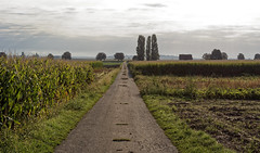
Straight
|
| |

Mercedes-Benz Intouro II n°FC-255-XP de LK Autocars Schmitt, sur le service 1 APEI Le Moulin Châtenois, aperçu peu après son départ, à la sortie de Blaesheim en juillet 2024
|

Mercedes-Benz Citaro Facelift n°079 (CF-356-VQ) de Stabus, affecté au réseau Trans-Cab d-Aurillac, probablement vendu ou en réparations, aperçu sur l-autoroute A35 en direction de Strasbourg en avril 2025
|
| |

Vineyard in mist
|

Spider in the web
|
| |

Mercedes-Benz Intouro III M Hybrid n°GZ-237-FB de LK Autocars Schmitt, garé au parking autocars de l-aéroport de Strasbourg-Entzheim, en décembre 2024
|

Les pommiers en février, par temps orageux
|
|
Old photos of the town of Dahlenheim
|
These photos taken near the town of Dahlenheim can be shown in full screen clicking on the thumbnails. Photos are copyrighted by their owners.
|
|
Other maps, hotels and towns in france
Find another town, zip code, department, region, ...
Quick links Dahlenheim :
Back to the menus Map of France :
Make a link to this page of Dahlenheim with the following code :
|
|
Map of France | Regions | Departments | Cities | Partners | Terms | Contact
|


