Map of France

Creuse
Department 23

French version French Version : Creuse

Find a town, a zip code,
a department, a region... in France
I like Map-France.com !


Department of Creuse - 23


Department of Creuse

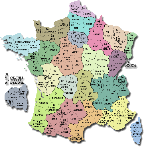
The department is the second level of administrative divisions on the map of France. 
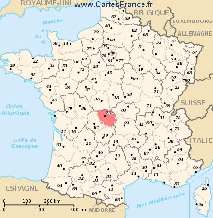
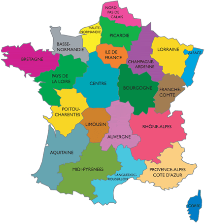
The department of Creuse is located in the region of region of Limousin.

The department of Creuse has the number 23 and is divided into 2 districts , 27 townships and 260 municipalities. Below you will find the localization of Creuse on the map of France, and the satellite map of Creuse.


Population of Creuse

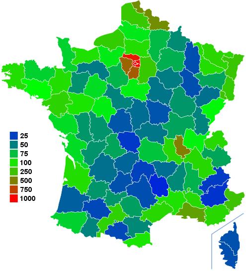
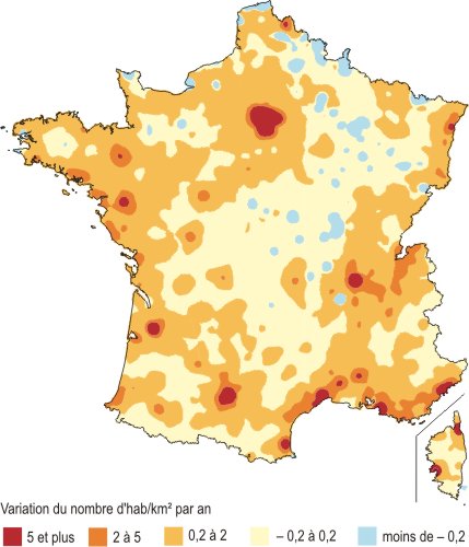
Inhabitants of Creuse were 124 470 in the 1999 census and 123 401 in the 2006 census. Area of departement of Creuse is 5 565,38 km ². Population density of Creuse is 22,17 inhabitants per km².

Biggest cities of department of Creuse, in number of inhabitants, are (2007 census): Guéret, La Souterraine, Aubusson, Bourganeuf, Sainte-Feyre, Saint-Sulpice-le-Guérétois, Felletin, Saint-Vaury, Ahun, Évaux-les-Bains, Gouzon, Boussac, Auzances, Bonnat, Le Grand-Bourg, Saint-Maurice-la-Souterraine, Dun-le-Palestel, Saint-Agnant-de-Versillat.

You will find the towns list of Creuse in the bottom on this page. You can consult the map of France, pictures, hotels, and all data of every town and village in the department of Creuse clicking on these towns links.


I like the department of
Creuse !
   
Biggest cities of Creuse
Name of biggest cities
of Creuse


Census
(2007)


Area
(km ²)


Density
(inh/km²)


Altitude
(m)


Guéret14 06626.21536.67431 m
La Souterraine5 37537.07145.00371 m
Aubusson4 18119.21217.65440 m
Bourganeuf2 94822.54130.79440 m
Sainte-Feyre2 24829.9974.96440 m
Saint-Sulpice-le-Guérétois1 99836.1855.22380 m
Felletin1 88913.74137.48520 m
Saint-Vaury1 85546.5039.89463 m
Ahun1 55733.7446.15460 m
Évaux-les-Bains1 54645.5533.94470 m
Gouzon1 45050.0328.98377 m
Boussac1 4121.48954.05367 m
Auzances1 3747.08194.07566 m
Bonnat1 31145.7928.63350 m
Le Grand-Bourg1 19478.9115.13385 m
Saint-Maurice-la-Souterraine1 18339.7229.78371 m
Dun-le-Palestel1 1479.81116.92365 m
Saint-Agnant-de-Versillat1 12450.4622.28310 m
Statistics of department of Creuse
Population 1999 124 470 inhabitants  
Population 2006 123 401 inhabitants  
Area 5 565.38 km ²  
Population density 22.17 inhabs/km² Map France population density
Variation of density -0.12 %/year Map France population variation density
     
Administration of department of Creuse
Number 23  
Prefecture Guéret  
Subprefectures Aubusson Map of France cities
Region Limousin (74) Map of France regions
     
Subdivisions of the department of Creuse
Districts 2  
Townships 27  
Municipalities 260  


Hotel Creuse

Search hotels of Creuse : Book your hotel now !

Where ? 

Check-in date 
calendar
Check-out date 
calendar


Book now ! Best Price Guaranteed, no booking fees, pay at the hotel with our partner Booking.com, leader in online hotel reservation.
 
Appartement L'Albuconis : Hotel near Creuse
Hotel Aubusson
Appartement L'Albuconis
Situated in Aubusson, Appartement L'Albuconis provides accommodation with a balcony and free WiFi. The property has garden and city views. This 2-bedroom apartment comes with a kitchen, ...
Rate : from 70.00 € to 75.00 €
Address : Appartement D 2eme Etage 29 Rue Jean Jaures 23200 Aubusson
Hotel de France : Hotel near Creuse
Hotel Aubusson
Hotel de France
Located in the heart of Aubusson, the world capital of tapestry art, Hotel de France welcomes you in the traditional setting of an 18th-century coaching inn. Hotel de France offers 21 re...
Price : from 99.00 € to 120.00 €
Contact : 6 Rue Des Déportés 23200 Aubusson
STUDIO D’HOTES : Hotel near Creuse
Hotel Guéret
STUDIO D’HOTES
STUDIO D’HOTES is located in Guéret. The accommodation is 42 km from Aubusson. The apartment features a kitchen with a dining area, 1 bathroom and a washing machine. A flat-screen TV ...
Prices : from 0.00 € to 0.00 €
Contact : 2 Allée du Chanoine Plazanet 23000 Guéret
Appartement d'Hôtes : Hotel near Creuse
Hotel Guéret
Appartement d'Hôtes
Located in the heart of Guéret, 66 km from Montluçon and 90 km from Limoges, Appartement d'hôtes offers a superior studio with free Wi-Fi and a private shower room. The living room ha...
Rate : from 0.00 € to 0.00 €
Contact : 15 avenue Fayolle 23000 Guéret


Map of Creuse

MAP OF THE CREUSE DEPARTMENT
map department Creuse

Where is located the Creuse department ?
The department of Creuse is located in the region of Limousin. Creuse is in red on the map of french departments.

What are the statistics and key data of Creuse ?
The department of Creuse has the number 23. It is composed of 2 districts ("arrondissements") , 27 townships ("cantons") and 260 towns ("communes").
The 2 districts of the department of Creuse are : Aubusson, Guéret.
The inhabitants of of Creuse were 124 470 in 1999 and 123 401 in 2006. The area of the department of Creuse is 5 565,38 km ². Population density of the department of Creuse is 22,17 inhabitants per km².


What are the largest cities of the department of Creuse ?
The largest cities of the department of Creuse (compared to the number of inhabitants in 2007) are : Guéret, La Souterraine, Aubusson, Bourganeuf, Sainte-Feyre, Saint-Sulpice-le-Guérétois, Felletin, Saint-Vaury, Ahun, Évaux-les-Bains, Gouzon, Boussac, Auzances, Bonnat, Le Grand-Bourg, Saint-Maurice-la-Souterraine, Dun-le-Palestel, Saint-Agnant-de-Versillat.

Interactive map of the Creuse department
You can zoom the satellite map of Creuse to see a village or a city, for example Guéret.

Search a town of departement of Creuse


Records of the Creuse department: Did you know ?


The town with the longest name of the department of Creuse is: Saint-Martin-Sainte-Catherine
The town with the shortest name of the department of Creuse is: Ars
The municipality with the highest altitude of the department of Creuse is: Féniers with 840 m
The municipality with the lowest altitude of the department of Creuse is: La Celle-Dunoise with 246 m
The municipality with the largest area of the department of Creuse is: Gentioux-Pigerolles with 79.29 km ²
The municipality with the smallest area of the department of Creuse is: Boussac with 1.48 km ²


Towns list of the Creuse department

Follow the links of towns and cities of the Creuse department and see photos, maps, and informations for these towns.


Towns of department of Creuse in A
AhunAjainAlleyratAnzême
Arfeuille-ChâtainArrènesArsAubusson
AugeAugèresAulonAuriat
AuzancesAzat-ChâtenetAzerables


Towns of department of Creuse in B
BanizeBasvilleBazelatBeissat
Bellegarde-en-MarcheBénévent-l'AbbayeBétêteBlaudeix
BlessacBonnatBord-Saint-GeorgesBosmoreau-les-Mines
BosrogerBourganeufBoussacBoussac-Bourg
BrousseBudelièreBussière-DunoiseBussière-Nouvelle
Bussière-Saint-Georges


Towns of department of Creuse in C
CeyrouxChamberaudChambon-Sainte-CroixChambon-sur-Voueize
ChambonchardChamborandChampagnatChampsanglard
ChardCharronChâtelardChâtelus-le-Marcheix
Châtelus-MalvaleixChavanatChénéraillesChéniers
ClairavauxClugnatColondannesCressat
CrocqCrozantCroze


Towns of department of Creuse in D
DomeyrotDontreixDun-le-Palestel


Towns of department of Creuse in E
Évaux-les-Bains


Towns of department of Creuse in F
Faux-la-MontagneFaux-MazurasFelletinFéniers
FlayatFleuratFontanièresFransèches
Fresselines


Towns of department of Creuse in G
GartempeGenouillacGentioux-PigerollesGioux
GlénicGouzonGuéret


Towns of department of Creuse in I
Issoudun-Létrieix


Towns of department of Creuse in J
JaleschesJanaillatJarnagesJouillat


Towns of department of Creuse in L
La BrionneLa Celle-DunoiseLa Celle-sous-GouzonLa Cellette
La Chapelle-BaloueLa Chapelle-Saint-MartialLa Chapelle-TaillefertLa Chaussade
La CourtineLa Forêt-du-TempleLa Mazière-aux-Bons-HommesLa Nouaille
La PougeLa SaunièreLa Serre-Bussière-VieilleLa Souterraine
La VilledieuLa VilleneuveLa VilletelleLadapeyre
LafatLavaufrancheLavaveix-les-MinesLe Bourg-d'Hem
Le ChauchetLe CompasLe DonzeilLe Grand-Bourg
Le Mas-d'ArtigeLe Monteil-au-VicomteLépaudLépinas
Les MarsLeyratLinardLioux-les-Monges
LizièresLourdoueix-Saint-PierreLupersatLussat


Towns of department of Creuse in M
Magnat-l'ÉtrangeMainsatMaison-FeyneMaisonnisses
MalleretMalleret-BoussacMalvalMansat-la-Courrière
MarsacMasbaraud-MérignatMautesMazeirat
MéasnesMérinchalMontaigut-le-BlancMontboucher
MortrouxMourioux-VieillevilleMoutier-d'AhunMoutier-Malcard
Moutier-Rozeille


Towns of department of Creuse in N
NaillatNéouxNothNouhant
NouzerinesNouzerollesNouziers


Towns of department of Creuse in P
ParsacPeyraboutPeyrat-la-NonièrePierrefitte
PionnatPontarionPontcharraudPoussanges
Puy-Malsignat


Towns of department of Creuse in R
ReterreRimondeixRochesRougnat
Royère-de-Vassivière


Towns of department of Creuse in S
SagnatSaint-Agnant-de-VersillatSaint-Agnant-près-CrocqSaint-Alpinien
Saint-AmandSaint-Amand-JartoudeixSaint-Avit-de-TardesSaint-Avit-le-Pauvre
Saint-BardSaint-ChabraisSaint-ChristopheSaint-Dizier-la-Tour
Saint-Dizier-les-DomainesSaint-Dizier-LeyrenneSaint-DometSaint-Éloi
Saint-Étienne-de-FursacSaint-FielSaint-FrionSaint-Georges-la-Pouge
Saint-Georges-NigremontSaint-Germain-BeaupréSaint-GoussaudSaint-Hilaire-la-Plaine
Saint-Hilaire-le-ChâteauSaint-Julien-la-GenêteSaint-Julien-le-ChâtelSaint-Junien-la-Bregère
Saint-LaurentSaint-Léger-BridereixSaint-Léger-le-GuérétoisSaint-Loup
Saint-MaixantSaint-Marc-à-FrongierSaint-Marc-à-LoubaudSaint-Marien
Saint-Martial-le-MontSaint-Martial-le-VieuxSaint-Martin-ChâteauSaint-Martin-Sainte-Catherine
Saint-Maurice-la-SouterraineSaint-Maurice-près-CrocqSaint-Médard-la-RochetteSaint-Merd-la-Breuille
Saint-Michel-de-VeisseSaint-MoreilSaint-Oradoux-de-ChirouzeSaint-Oradoux-près-Crocq
Saint-Pardoux-d'ArnetSaint-Pardoux-le-NeufSaint-Pardoux-les-CardsSaint-Pardoux-Morterolles
Saint-Pierre-BellevueSaint-Pierre-ChérignatSaint-Pierre-de-FursacSaint-Pierre-le-Bost
Saint-PriestSaint-Priest-la-FeuilleSaint-Priest-la-PlaineSaint-Priest-Palus
Saint-Quentin-la-ChabanneSaint-SébastienSaint-Silvain-Bas-le-RocSaint-Silvain-Bellegarde
Saint-Silvain-MontaigutSaint-Silvain-sous-ToulxSaint-Sulpice-le-DunoisSaint-Sulpice-le-Guérétois
Saint-Sulpice-les-ChampsSaint-VaurySaint-Victor-en-MarcheSaint-Yrieix-la-Montagne
Saint-Yrieix-les-BoisSainte-FeyreSainte-Feyre-la-MontagneSannat
SardentSavennesSermurSoubrebost
SoumansSous-Parsat


Towns of department of Creuse in T
TardesTercillatThauronToulx-Sainte-Croix
Trois-Fonds


Towns of department of Creuse in V
VallièreVareillesVerneigesVidaillat
ViersatVigevilleVillard


List of french departments


Ain
Aisne
Allier
Alpes de Haute-Provence
Hautes-Alpes
Alpes Maritimes
Ardèche
Ardennes
Ariège
Aube
Aude
Aveyron
Bouches-du-Rhône
Calvados
Cantal
Charente
Charente-Maritime
Cher
Corrèze
Corse-du-Sud
HauteCorse
Côte-d'Or
Côtes d'Armor
Creuse
Dordogne

Doubs
Drôme
Eure
Eure-et-Loir
Finistère
Gard
Haute Garonne
Gers
Gironde
Hérault
Ille-et-Vilaine
Indre
Indre-et-Loire
Isère
Jura
Landes
Loir-et-Cher
Loire
Haute Loire
Loire Atlantique
Loiret
Lot
Lot-et-Garonne
Lozère
Maine-et-Loire

Manche
Marne
HauteMarne
Mayenne
Meurthe-et-Moselle
Meuse
Morbihan
Moselle
Nièvre
Nord
Oise
Orne
Pas-de-Calais
Puy-de-Dôme
Pyrénées Atlantiques
Hautes Pyrénées
Pyrénées Orientales
Bas-Rhin
Haut-Rhin
Rhône
Haute Saône
Saône-et-Loire
Sarthe
Savoie
Haute Savoie

Paris
Seine Maritime
Seine-et-Marne
Yvelines
Deux-Sèvres
Somme
Tarn
Tarn-et-Garonne
Var
Vaucluse
Vendée
Vienne
Haute Vienne
Vosges
Yonne
Territoire de Belfort
Essonne
Hauts-de-Seine
Seine-St-Denis
Val-de-Marne
Val-D'Oise
Guadeloupe
Martinique
Guyane
La-Reunion
Mayotte


Other departments, regions, maps, hotels and towns in france


Find another town, zip code, department, region, ...


Back to the menus Map of France :


Make a link to this pageVillard with the following code :


Find a town in France by clicking on the following interactives maps :


MAP OF FRANCE REGION


Map of french regions


Map of french regions Alsace Lorraine Franche Comte Champagne Ardenne Nord pas de Calais Picardie Haute Normandie Basse Normandie Bretagne Pays de la Loire Poitou Charentes Limousin Centre Ile de France Bourgogne Rhone Alpes Auvergne Provence Midi Pyrenees Aquitaine Languedoc Rousillon Corse

MAP OF FRANCE DEPARTMENT


Map of french departments
Map of french departments Map France department Nord 59 [15] Map France department Pas de Calais 62 [15] Map France department Somme 80 [19] Map France department Aisne 02 [19] Map France department Oise 60 [19] Map France department Seine Maritime 76 [17] Map France department Eure 27 [17] Map France department Ardennes 08 [07] Map France department Marne 51 [07] Map France department Aube 10 [07] Map France department Haute Marne 52 [07] Map France department Meuse 55 [13] Map France department Meurthe et Moselle 54 [13] Map France department Moselle 57 [13] Map France department Vosges 88 [13] Map France department Bas Rhin 67 [01] Map France department Haut Rhin 68 [01] Map France department Territoire de Belfort 90 [09] Map France department Haute Saône 70 [09] Map France department Doubs 25 [09] Map France department Jura 39 [09] Map France department Haute Savoie 74 [22] Map France department Ain 01 [22] Map France department Rhône 69 [22] Map France department Loire 42 [22] Map France department Savoie 73 [22] Map France department Isère 38 [22] Map France department Drôme 26 [22] Map France department Ardèche 07 [22] Map France department Hautes Alpes 05 [21] Map France department Alpes de Haute Provence 04 [21] Map France department Alpes Maritimes 06 [21] Map France department Var 83 [21] Map France department Vaucluse 84 [21] Map France department Bouches du Rhône 13 [21] Map France department Haute Corse 2B [08] Map France department Corse du Sud 2A [08] Map France department Yonne 89 [04] Map France department Côte d'Or 21 [04] Map France department Saône et Loire 71 [04] Map France department Nièvre 58 [04] Map France department Calvados 14 [16] Map France department Manche 50 [16] Map France department Orne 61 [16] Map France department Eure et Loir [06] Map France department Loiret 45 [06] Map France department Loir et Cher 41 [06] Map France department Cher 18 [06] Map France department Indre et Loire 37 [06] Map France department Indre 36 [06] Map France department Allier 03 [03] Map France department Puy de Dôme 63 [03] Map France department Haute Loire 43 [03] Map France department Cantal 15 [03] Map France department Finistère 29 [05] Map France department Côtes d'Armor 22 [05] Map France department Ille et Vilaine 35 [05] Map France department Morbihan 56 [05] Map France department Mayenne 53 [18] Map France department Sarthe 72 [18] Map France department Maine et Loire 49 [18] Map France department Loire Atlantique 44 [18] Map France department Vendée 85 [18] Map France department Deux sèvres 79 [20] Map France department Vienne 86 [20] Map France department Charente Maritime 17 [20] Map France department Charente 16 [20] Map France department Creuse 23 [12] Map France department Haute Vienne 87 [12] Map France department Corrèze 19 [12] Map France department Dordogne 24 [02] Map France department Gironde 33 [02] Map France department Lot et Garonne 47 [02] Map France department Landes 40 [02] Map France department Pyrénées Athlantiques 64 [02] Map France department Lot 46 [14] Map France department Aveyron 12 [14] Map France department Tarn 81 [14] Map France department Tarn et Garonne 82 [14] Map France department Gers 32 [14] Map France department Haute Garonne 31 [14] Map France department Hautes Pyrénées 65 [14] Map France department Ariège 09 [14] Map France department Lozère 48 [11] Map France department Gard 30 [11] Map France department Hérault 34 [11] Map France department Aude 11 [11] Map France department Pyrénées Orientales 66 [11] Map France department Seine et Marne 77 [10] Map France department Essonne 91 [10] Map France department Yvelines 78 [10] Map France department Val d'Oise 95 [10]


Map of France | Regions | Departments | Cities | Partners | Terms | Contact

French version French version :  Creuse | Carte de France